
Basin countries Czech Republic Average depth 15.5 m (51 ft) Surface elevation 137 m Mean depth 16 m Lake type Reservoir | Surface area 2.5 km (1.6 mi) Max. depth 22 m (72 ft) Area 250 ha Outflow location Bílina | |
 | ||
Water volume 35,000,000 m (1.2×10 cu ft) Settlements Chabařovice, Ústí nad Labem Cities Ústí nad Labem, Chabařovice | ||
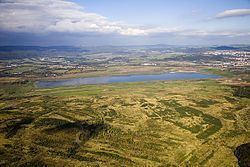
Chabařovice Lake /ˈkɑː.bɑːˌrʒoʊ.vɪˌtsɛ/ (Czech: Chabařovické jezero), also known as Milada, is a reservoir in the Czech Republic. It originated from excavation by an old coal mine and flooded former villages, Hrbovice, Tuchomyšl and Vyklice. The lakes surface area stretchs 250 ha, which makes it slightly smaller than nearby Lake Mácha. Its average depth is 15.5 meters and its maximum depth is 22 m. The capacity is approximately 35 mil. m3.
Contents
Map of jezero Milada, Czechia
Water modeEdit
In 1998, the mining of brown coal in Chabařovice ceased and the quarry was closed. Recultivation work started subsequently. The former Chabařovice quarry was the first of large surface mines within the Czech Republic in which redevelopment and reclamation works, after termination of mining, came to the stage when the remnant den was filled with water. It became a model for other localities.
The watering has been in progress since 15 June 2001. The reservoir is the second largest reclaimed lake within northern Czech Republic. The recultivation is based on the hydric system, concretely the watering. The maximum watering speed is 700 l/s and is processed by a water relief from the Kateřina reservoir. At the present time some land is being prepared for investment and the area is being opened to the public. Mild local climate change is expected in the direct surroundings following the creation of the lake, such as an increase in fogs, less dustiness and temperature stabilization.
The water quality is one of the key criteria, which is monitored and will be helpful for projection of the hydric recultivation in another region.
UtilizationEdit
The lake will be partly used for recreational purposes.
In 2006 originated the Association of five communes called Jezero Milada (Lake Milada). These five communes are Ústí nad Labem, Chabařovice, Trmice, Řehlovice and Modlany. The financial resources of the Association and the municipality Ústí nad Labem were used on setting out the Cycling path 3009. Cycling path with marking 3009 was opened in 2006 and it goes through the territory of outside dump of the mine with line up to Habří and Řehlovice. In Chabařovice it connects the already built cycling path KČT (Club of Czech Tourists) with the same marking, then it goes around lake, diverges across paths in the area and finally it leads to Stadice. Here it lines-up cycling path of Přemysl Oráč (no. 3071), which leads to Trmice or the other direction to Úpořiny.
Future utilization as recreational and sporting area – bathing, swimming, fishing, sailing, bike route, roller skating, jogging, horse riding etc..