
Area 15 km² | Elevation 600 ft (200 m) Province Quang Nam Province | |
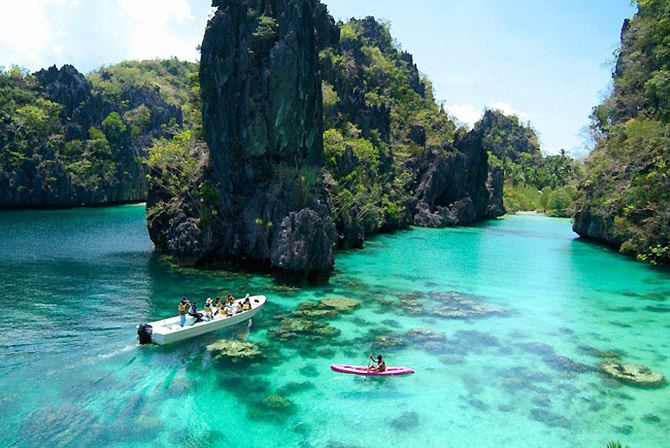 | ||
The Cham Islands (Vietnamese: Cù lao Chàm) constitute a group of 8 small islands of Quảng Nam, which form a part of the Cu Lao Cham Marine Park, a world Biosphere Reserve recognized by UNESCO, in the South East Asia Sea in Vietnam. The islands are approachable from Cửa Đại beach. The islands are also recognized as Vietnam's national scenic site.
Contents
- Map of CC3B9 Lao ChC3A0m TC3A2n HiE1BB87p HE1BB99i An Quang Nam Province Vietnam
- Geography
- History
- References
Map of C%C3%B9 Lao Ch%C3%A0m, T%C3%A2n Hi%E1%BB%87p, H%E1%BB%99i An, Quang Nam Province, Vietnam
The islands grouped under the Cham Islands are: the Hòn Lao (Pearl), Hòn Dài (long), Hòn Mồ (tomb), Hòn Khô mẹ, Hòn Khô con (dry), Hòn Lá (leaf), Hòn Tai (ear) and Hòn Ông (east wind). The Cham Islands are under the administration of Tân Hiệp Commune of Hội An city in Quảng Nam Province.
The occupation of the people of the islands is mainly fishing.
Cu Lao Cham Islands' ancient landscape offers many sand beaches, forested hills and the sea. Facilities for camping, swimming and scuba diving are available. The corals and marine life are an attraction in these island waters.
Geography
Cu Lao Cham island group is an lower extension in SE of the granite block named Bach Ma - Hai Van - Son Tra belonging to the Hai Van complex of early Triassic age, mainly composed of biotite granite and two-mica granites [1].
The agglomeration of the one large island surrounded by seven small islands cover a sea area of 15 square kilometres (5.8 sq mi); located in South East Asia Sea, 16 kilometres (9.9 mi) from the coast and 19 kilometres (12 mi) to the east of ancient Hội An town.
The largest island, circular in shape, has an area of 1,317 hectares (3,250 acres) with an average altitude of 500 metres (1,600 ft); the two peaks seen on the island are: one a 517 metres (1,696 ft) peak in the centre of the island and another 326 metres (1,070 ft) peak at the western end. On this largest island, the two fishing villages are Bai Lang with docking piers and the smaller village is called Bai Huong. Bai Chong Beach is the most impressive beach on the island. The islands fall under the administrative jurisdiction of Hội An and acts as a defensive wall for the ancient town.
Seafarers were attracted to these ancient islands for favourable anchorage facilities off the Bai Lang village on Hon Lao island where fresh water supply was also located. This is corroborated by early Chinese charts from 700 AD.
The islands are approached by canoeing over three hours journey or by speed boats in about half hour from the nearest coastal shore point.
History
Archaeologists claim that Cham Islands were first settled by Cham people about 3,000 years ago. However, business contacts were established with other countries about 1,000 years ago. The Cham islands were used for transhipment to the mainland by the Cham. Many architectural monuments dated to the 18th and 20th century are reported, which include Than Yen Sao shrine built in 1843 at Bai Huong, and Hai Tang Pagodas built in 1753 on the western hillside of Hon Lao. Small monuments, Dikes and basins to grow rice on terraces are also seen in the interior forest areas.