
Time zone CET (UTC+1) Local time Wednesday 3:20 PM Postal code 25040 | Demonym(s) Cevesi Elevation 1,100 m | |
 | ||
Frazioni Fresine, Andrista, Isola Weather 11°C, Wind SW at 6 km/h, 25% Humidity | ||
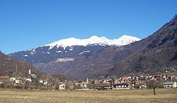
Cevo (Séf in local camunian dialect) is an Italian comune of 938 inhabitants in Val Camonica, province of Brescia, in Lombardy.
Contents
- Map of 25040 Cevo Province of Brescia Italy
- Geography
- History
- Religious architectures
- Traditions and folklore
- Twin towns
- References
Map of 25040 Cevo, Province of Brescia, Italy
Geography
Neighbouring communes are Saviore dell'Adamello and Berzo Demo. It is located near Valle Camonica near the slopes of Adamello.
History
On April 22, 1644, most of the town of Cevo was burned down by a fire started by lightning. On July 3, 1944, most of the houses in the town were either damaged, destroyed, or looted by the combined Wehrmacht and Italian Fascist forces, in retaliation for activities by the partisans. Six people were killed and two-thirds of the 1,200 residents were left homeless.
Religious architectures
Churches Cevo are:
Traditions and folklore
The scütüm are in camunian dialect nicknames, sometimes personal, elsewhere showing the characteristic features of a community. The one which characterize the people of Cevo is Barlócc.
Twin towns
Cevo is twinned with: