
Elevation 15 m (49 ft) Area 4.91 km² Local time Wednesday 2:44 PM | Frazioni Fuenti Demonym(s) Cetaresi Postal code 84011 | |
 | ||
Weather 12°C, Wind N at 21 km/h, 57% Humidity | ||
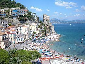
Cetara is a town and comune in the province of Salerno in the Campania region of south-western Italy. It is located in the territory of the Amalfi Coast.
Contents
Map of 84010 Cetara Province of Salerno, Italy
History
The village was originally a settlement for a group of armed Muslims in 880. Characterized to be a village of fishermen (especially of tuna), its name take origins probably from the Latin word Cetaria (in Greek Ketèia), meaning almadraba (in Italian tonnara); or cetari, meaning fishmongers of big fishes.
Geography
Cetara is located by the Tyrrhenian Sea, on the Amalfi Drive road between the "Marina" of Albori and Erchie, bordering with the municipalities of Vietri sul Mare and Maiori. Its municipalities is extended from the coast to the Mount Falerio and counts only one civil parish (frazione): the little village of Fuenti, situated on the hills close to the Amalfi Drive.