
Length 10.7 km (6.6 mi) | Basin size 24 km (9.3 sq mi) | |
 | ||
Main source Ligurian Apennines376 m (1,234 ft) River mouth | ||
The Cerusa is a 10.7-kilometre (6.6 mi) stream of Liguria (Italy).
Contents
Geography
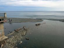
The river is formed at 376 m by the confluence of two streams, Rio Gava and Rio delle Cave, in the Ligurian Apennines. The river then flows through the Valle Cerusa and crosses the villages of Fiorino, Fabbriche di Voltri e Fullo. Heading south reaches Voltri and ends its course in the Ligurian Sea, after being crossed by Autostrada A10, Genoa–Ventimiglia railway and Aurelia national road.
Cerusa basin (24 km2) is totally included in the Province of Genova.
Main tributaries
History
The Département de la Ceruse or Dipartimento della Cerusa of Ligurian Republic took its name at the end of the XVIII century from the stream.
References
Cerusa Wikipedia(Text) CC BY-SA