
Elevation 2,730 m (8,960 ft) | ||
 | ||
Location | ||
Cerro del chiquihuite
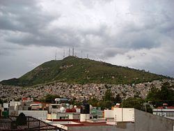
Cerro del Chiquihuite (Chiquihuite Hill) is a hill located in the north of Mexico City, in the borough of Gustavo A. Madero and bordering the municipality of Tlalnepantla de Baz in the State of Mexico. The hill has a height of 2,730 metres (8,960 ft) above sea level and forms part of the Sierra Guadalupe mountain range.
Contents
- Cerro del chiquihuite
- Map of Cerro del Chiquihuite Zona de ConservaciC3B3n EcolC3B3gica 07259 Mexico City CDMX Mexico
- Geology
- The chiquihuitazo
- 15th Century The Templo Mayor
- Broadcasting
- Television stations
- Radio stations
- References
Map of Cerro del Chiquihuite, Zona de Conservaci%C3%B3n Ecol%C3%B3gica, 07259 Mexico City, CDMX, Mexico
It was used as a filming location for the 1993 Mexican film Lolo.
Geology
The Cerro del Chiquihuite is a volcanic exogenic dome made of andesitic rock deposited in layers of varying thickness that show signs of extreme weathering. In the past, Chiquihuite had springs of water scattered over its surface, but with the passing of years, these springs have diminished in size.
Historically the mountain has housed several springs, but most of these have dried up. For instance, in the borough of Lázaro Cárdenas, only the largest of these, known as "El Pocito", still flows.
The mountain is rather heavily developed and is prone to landslides; in 1987, 15 people were killed by mudslides off Cerro del Chiquihuite and La Presa hills after heavy rains hit Mexico City.
The chiquihuitazo
On December 27, 2002, armed guards hired by Televisión Azteca stormed and took over the transmitter facilities of XHTVM-TV channel 40, which are located on the mountain. The takeover, which stemmed from a contractual and legal dispute over a 1998 contract between XHTVM's owners and Azteca, led to a series of events, negotiations and public debate known as the chiquihuitazo, after the mountain, that resulted in XHTVM's owners rebuffing Azteca's forceful attempt to retake the station.
The chiquihuitazo resulted in a song, "No Te Metas con mi Chiquihuite" (Don't Mess with My Chiquihuite), produced by a program that aired on Canal 40 at the time.
15th Century: The Templo Mayor
During the 15th century, the Cerro del Chiquihuite was located on the shores of Lake Texcoco, some 9 to 12 kilometers from the heart of the Aztecan empire, Tenochtitlán. The Cerro del Chiquihuite was made principally of a pinkish and violet rock called andesita de lamprobolita, an extrusive igneous rock. One of the principle merits of this rock is the pseudo stratification of its deposited layers of varying thickness. This characteristic allows for flat cuts of stone to be obtained with ease to be used for the tiling of the floor, corners and overhead masonry. Among the towns located in the basin of Mexico, this type of rock was known as Tenayocátetl (Piedra de Tenayuca), and was used in the construction of the Templo Mayor.
Broadcasting
A road leads to the top of the mountain, where transmitters are located for nine FM radio stations and eleven television stations, as well as other telecommunications equipment.
Television stations
Radio stations
Five stations owned by Grupo Radio Centro maintain backup facilities on Cerro del Chiquihuite. They were relocated to a new facility at Villa Alpina, Naucalpan, State of Mexico, in August 2012.