
Elevation 2,994 m | ||
 | ||
Similar Pico da Neblina, Pico 31 de Março, Cerro Marahuaca, Cerro Duida, Chimantá Massif | ||
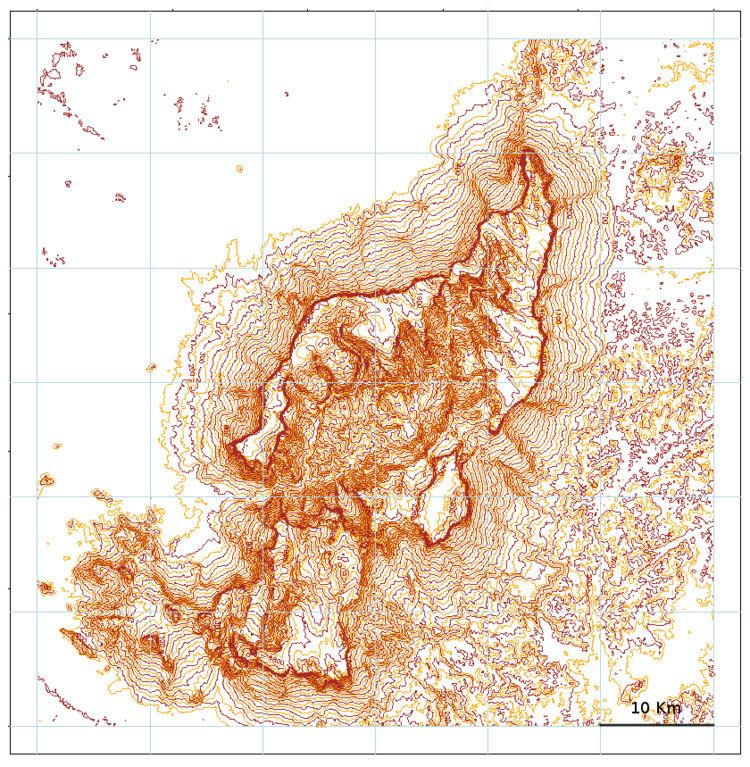
Cerro de la Neblina (lit. "Mountain of the Mist"), also known as Serra da Neblina in Brazil and Sierra de la Neblina in Venezuela, is a sandstone massif located in the northern Amazon Basin. It is a tilted, heavily eroded plateau, with a deep canyon in its central portion (Cañón Grande), drained by the Baria River. The southeastern ridge of the massif forms part of the Brazil–Venezuela border, and it is where the massif reaches its highest elevation, the Pico da Neblina in Brazilian territory. At 2,994 metres (9,823 ft) above sea level, this is the highest mountain of the entire Guayana Shield. The slightly shorter Pico 31 de Março / Pico Phelps lies a few hundred metres away on the border itself and is Brazil's second-highest mountain, and the highest mountain in Venezuela outside of the Andes. The massif's other named peaks include Pico Cardona, Pico Maguire, and Pico Zuloaga. To the north of Cerro de la Neblina lie the smaller outcrops of Cerro Aracamuni and Cerro Avispa, both reaching approximately 1,600 metres (5,200 ft) in elevation.
Map of Cerro de la Neblina, Amazonas, Venezuela
The massif was first explored in 1954 by an American expedition led by Bassett Maguire that performed an aerial inspection and then climbed the massif's northwestern slopes. In January 1999, a group of carnivorous plant enthusiasts climbed Pico da Neblina following a 30 km hike up the previously unexplored northeastern ridge.
Cerro de la Neblina is sometimes referred to as the Neblina Massif, though this term may also encompass Cerro Aracamuni and Cerro Avispa (a grouping of mountains more precisely known as the Neblina–Aracamuni Massif). The Neblina–Aracamuni Massif has a total summit area of roughly 473 km2 (183 sq mi) and an estimated slope area of 1,515 km2 (585 sq mi), of which Cerro de la Neblina accounts for 235 km2 (91 sq mi) and 857 km2 (331 sq mi), respectively.