
 | ||
Similar Cerro Blanco, Santiago Metropolitan Park, San Cristóbal Hill, Mapocho River, Parque de Los Reyes | ||
Downhill cerro renca
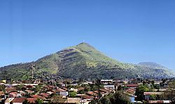
Cerro Renca is a hill straddling the border between Quilicura to the north and Renca to the south, in the city of Santiago, Chile. This geographic feature rises 300 metres (980 ft) above the surrounding terrain. The hill, which is 905 m (2,969 ft) above sea level at its highest point, has two subsidiaries summits known as Cerro Colorado (720 m (2,360 ft) AMSL) and Puntilla Lo Ruiz (720 m (2,360 ft) AMSL).
Contents
- Downhill cerro renca
- Map of Cerro Renca Renca Santiago Metropolitan Region Chile
- En la cima del cerro renca septiembre 2012
- References
Map of Cerro Renca, Renca, Santiago Metropolitan Region, Chile
En la cima del cerro renca septiembre 2012
References
Cerro Renca Wikipedia(Text) CC BY-SA