
Translation Hill | Elevation 224 m Easiest route Hiking | |
 | ||
Similar Cerro Cementerio, Cerro de las Ánimas, Cerro Pan de Azúcar | ||
Cerro batov intercanaltv com tacuaremb uruguay
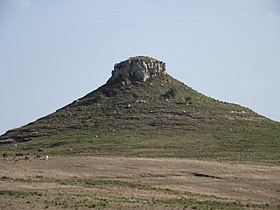
Cerro Batoví is a hill in Uruguay, with an altitude of 224 metres (734.9 ft). It is situated 25 km (15.5 mi) away from the city of Tacuarembó.
Contents
- Cerro batov intercanaltv com tacuaremb uruguay
- Map of Cerro BatovC3AD TacuarembC3B3 Department Uruguay
- Tacuaremb cerro batov d
- Location and features
- References
Map of Cerro Batov%C3%AD, Tacuaremb%C3%B3 Department, Uruguay
Tacuaremb cerro batov d
Location and features
It is located in the Tacuarembó Department, in a range of hills named Cuchilla de Haedo. Batoví means breast of a virgin in the Guaraní language and the hill has this name due to its curious shape.
Cerro Batoví is considered the symbol of the Tacuarembó Department.
References
Cerro Batoví Wikipedia(Text) CC BY-SA