
Prominence 1,900 m (6,200 ft) Volcanic arc/belt South Volcanic Zone Last eruption 1979 Listing Ultra-prominent peak | Elevation 3,437 m First ascent 1958 Parent range Andes | |
 | ||
Similar Caichinque, Cerro del Azufre, Cochiquito Volcanic Group, Yanteles, Apagado | ||
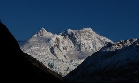
Cerro arenales 3400m vallecitos
Cerro Arenales is a heavily ice-covered stratovolcano located in the Aysén del General Carlos Ibáñez del Campo Region of Chile, within Laguna San Rafael National Park. It towers over the southern part of the Northern Patagonian Ice Field. Arenales has a summit elevation of 3,437 meters (11276 feet) above sea level.
Contents
- Cerro arenales 3400m vallecitos
- Map of Cerro Arenales Cochrane XI RegiC3B3n Chile
- Cumbre cerro arenales treeking fotografico
- Climbing
- References
Map of Cerro Arenales, Cochrane, XI Regi%C3%B3n, Chile
Cumbre cerro arenales treeking fotografico
Climbing
The first ascent of Cerro Arenales was made in 1958 by a Japanese-Chilean expedition, headed by Professor Tanaka. In December 1963 an expedition led by Eric Shipton, crossed the NPIF heading southeast from Laguna San Rafael to Río de la Colonia and accomplished on the way the second ascent.
References
Cerro Arenales Wikipedia(Text) CC BY-SA