
Length 30 km | Basin size 17.80 sq mi (46.1 km) Basin area 46.1 km² | |
 | ||
Main source Barrio Anón1,200 feet (370 m) River mouth Río Bucaná69 feet (21 m) Progression AnónMaraguezCerrillos Tributaries Left:Río BayagánQuebrada AusuboRío San PatricioRight:Río Prieto | ||
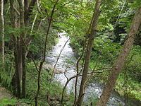
Cerrillos River (Spanish: Río Cerrillos) is a river in the municipality of Ponce, Puerto Rico. Río Cerrillos has its origin in barrio Anón and runs south until it feeds into Bucaná River. Río Cerrillos is commonly known by the locals as Maragüez River, because most of its course runs through Barrio Maragüez. This river is one of the 14 rivers in the municipality. The river has a discharge of 24,000 cubic feet per second, making it the second most affluent river in the municipality after Río Jacaguas.
Contents
Map of R%C3%ADo Cerrillos, Ponce, Puerto Rico
Course
From its origin about 1 kilometer south of the intersection of PR-139 and PR-143, Río Cerrillos runs south for 1.8 kilometers where it is fed by Río Prieto west of PR-139. From this point on, Rio Cerrillos runs parallel to PR-139 for 2 kilometers in barrio Anón before reaching barrio Maraguez. Continuing on its southernly course for about 1.2 kilometers, Río Cerrillos is fed by Río San Patricio. Five kilometers further downstream Río Cerrillos forms Lake Cerrillos, as a result of its dam. Flowing out of the Cerrillos dam, Río Cerrillos runs south for 1 kilometer until it enters barrios Machuelo Arriba and barrio Cerrillos, being the boundary between the two barrios. The river continues its southern course parallel to PR-139 for 5 kilometers until it reaches PR-5139. In another kilometer downstream it is fed by Quebrada Ausubo, and another kilometer further south it is fed by Río Bayagán. At this point it feeds into Río Bucaná where it terminates.
Cerrillos Lake and Dam
Cerrillos is the feeder river for Lake Cerrillos Dam in Barrio Maragüez, in the municipality of Ponce. The lake is an artificial reservoir holding 47,900 acre-feet (59,100,000 m3) of water. The dam that made the lake possible was completed in 1992. The lake is surrounded by the Cerrillos State Forest north of the dam. The area immediately south of the dam is a park, the Luis A. Wito Morales Park.