
 | ||
There has long been debate over the exact location of the geographical centre of the United Kingdom, and its constituent countries, due to the complexity and method of the calculation, such as whether to include offshore islands, and the fact that erosion will cause the position to change over time. There are two main methods of calculating this "centre": either as the centroid of the two-dimensional shape made by the country (projected to the Airy ellipsoid then flattened using the Transverse Mercator projection), or as the point farthest from the boundary of the country (either the sea, or, in the case of constituent countries, a land border). These two methods give quite different answers.
Contents
Traditional locations
The town of Haltwhistle in Northumberland has banners stating that it is the "Centre of Britain". By another calculation the centre can also be said to be Dunsop Bridge, Lancashire (historically in the West Riding of Yorkshire), 71 miles (114 km) to the south.
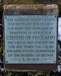
For centuries the parish of Meriden to the west of Coventry has claimed to be the geographical centre of England, and there has been a stone cross there commemorating the claim for at least 500 years. The justification is that the point farthest from the sea is in the parish. Morton, Derbyshire also claims to be the centre of England as it is not only mid-way along England's longest north-south axis, but also midway between the east coast and the Welsh border. Claims are also made for a tree, the Midland Oak, on the boundary between Lillington and Leamington Spa, Warwickshire, although the basis for these claims is not clear.
However, in 2002 the Ordnance Survey conducted studies that pinpointed the respective centres more precisely, and it is their results that are quoted below.
Centroid locations
Put simply, the centroid is the point at which a cardboard cut-out of the area could be perfectly balanced on the tip of a pencil. Islands are assumed fixed to the mainland in their precise position by invisible rigid weightless wires. A mathematical method is used to do the balancing to a much greater accuracy than the practical method could achieve.
Unless stated, positions are the centroids of the two-dimensional shapes made by the countries. Calculations include offshore islands unless stated.
Great Britain
Great Britain (excluding islands other than the island of Great Britain itself)
England
Northern Ireland
Scotland
Wales
United Kingdom of Great Britain and Northern Ireland
Locations found by other methods
Point farthest from the sea
Point farthest from high tide mark (including tidal rivers)
Centre of a rectangle enclosing precisely all of England and Wales
Mid point of the longest north–south axis
Centre of population