
Area 8.3 km² | Subprefectures Central ZoneSé | |
 | ||
Similar Vale do Anhangabaú, Centro histórico de São Paulo, São Paulo Cathedral, Luz Station, Avenida São João | ||
The Central Zone (Portuguese: Zona Central de São Paulo) is an administrative zone of the city of São Paulo, Brazil.
Contents
- Map of Central Zone of SC3A3o Paulo SC3A3o Paulo State of SC3A3o Paulo Brazil
- Limits
- Social Characteristics
- Viaducts
- Avenue and Streets
- Squares
- Metro and commuter railway stations
- Major Shopping Centers
- Major Parks
- Colleges and universities
- Hospitals
- Culture and Leisure
- Rivers
- Buildings
- Sightseeing
- References
Map of Central Zone of S%C3%A3o Paulo, S%C3%A3o Paulo - State of S%C3%A3o Paulo, Brazil
One of the largest commercial and business districts in South America, the region is administered by the subprefecture of Sé. It is not concurrent, although often confused, with the regions known as Centro Expandido ("Expanded Center"), a broader area used by the city government for urban planning and road space rationing actions and Centro Histórico de São Paulo ("São Paulo Historic Center"), which, as the name implies, includes only the oldest part of the central region.
Limits
Officially, the central area is bounded by districts of Municipality Cathedral. However, the social perception of what is called "center of São Paulo" varies and may include other areas of city. Until the creation of the administrative office of the Cathedral, the notion of "center" was equivalent to the region of the former administration regional office, who also included the districts of Brás and Pari, currently covered by an Municipality of Mooca. The concept of a central area of São Paulo, however, is wider depending on the study is done about the region and may include items such as financial centers Paulista Avenue and Berrini.
Social Characteristics
According to the 2000 census, the total population of the area is 374,002 inhabitants, including the neighborhoods and districts of Sé itself, Bela Vista, Bom Retiro, Cambuci, Consolação, Aclimação, Brás, Liberdade, República and Santa Cecília. It is the least populated administrative region in the city, albeit one with a wider range of public facilities and jobs. The average income in the area is R$ 2335.54, and each year the central area of São Paulo has a rate negative of population growth that reaches 5% per year, according to IBGE and SEADE statistics.
This factor contributed to what has been called degradation the region, as some experts in urban studies, with the removal of the São Paulo elite of the central areas, occurs along the removal of public stewardship, leading to a sense of abandonment. Despite showing an average income higher than that of other regions of the city, it has many homeless individuals and pockets of poverty, such as the region known as Cracolândia (lit. "Crackland"), which has recently been undergoing a controversial process of revitalization by the city government, accused of promoting "social hygiene" through gentrification.
The Centro region is the most well-served by public transportation, with four of the five Metrô subway lines operating in the area, along with several CPTM commuter rail lines. It is also home to some of the major institutions of higher education in the city, as Mackenzie University, The Armando Alvares Penteado Foundation (FAAP) and units of the University of São Paulo (USP), like Law School, The University Center on Maria Antonia Street, and the headquarters of the USP Post-Graduate School of Architecture and Urban Affairs.
Viaducts
Avenue and Streets
Squares
Metro and commuter railway stations
Major Shopping Centers
Major Parks
Colleges and universities
Hospitals
Culture and Leisure
Rivers
Buildings
Major buildings in the central zone of São Paulo:
Sightseeing
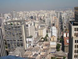
Torre Banespa ("Banespa Tower"), situated on the highest point of the Altino Arantes Building and Edifício Itália are the main sightseeing places in the region and São Paulo as a whole, providing a privileged views of the city with a range of up to 40 kilometers, making it possible to see other city landmarks such as the Mercado Municipal, the São Paulo Cathedral, Edifício Copan and even Serra da Cantareira at distance. Mirante do Vale Building, completed in 1960, although not well known as a sightseeing place due to its location at the bottom of a valley, is still the tallest building in Brazil.