
Country United States County Allegheny County Area 67 ha | State Pennsylvania City Pittsburgh Population 2,923 (2010) | |
 | ||
Restaurants El Burro Comedor, Lola Bistro, Rasta House, Deli on North, Wilson's Bar‑B‑Q | ||
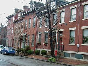
Central Northside is a neighborhood in the North Side of the city of Pittsburgh, Pennsylvania, USA. It has a zip code of 15212, and has representation on Pittsburgh City Council by the council member for District 6 (Downtown/Northshore Neighborhoods). Originally known as "The Buena Vista Tract", it is densely filled with restored row houses, community gardens and tree lined streets and alleyways.
Contents
- Map of Central Northside Pittsburgh PA USA
- History
- Mexican War Streets
- Fictional Portrayals
- Name
- References
Map of Central Northside, Pittsburgh, PA, USA
History
In the late 19th century, Allegheny, Pennsylvania (later annexed by Pittsburgh) became known for its stately homes, occupied by some of the area's wealthy families. One such area became known as the Mexican War Streets.
Mexican War Streets
The Mexican War Streets were laid out in 1848 by General William Robinson, Jr. who later became mayor of the city of Allegheny. Just returned from service in the Mexican–American War, he subdivided his land and named the new streets after the battles and generals (Buena Vista Street, Filson Way, Monterey Street, Palo Alto Street, Resaca Place, Sherman Avenue, Taylor Avenue) of that war.
Fictional Portrayals
Name
On 10 September 2012, the Central Northside Neighborhood Council (CNNC) voted to change the neighborhood's name to Allegheny City Central. However, according to an FAQ published by the CNNC in August 2012, the Council reported that official city maps would "probably not" reflect the name change and that the city planning department is "always very reluctant" to alter established names. The same document refers to the name change as a "branding initiative" which is part of a "new brand and marketing strategy".