
 | ||
Restaurants El Taco Mexicano, Granny's Kitchen Southern, dominos, Tinchy's BBQ, Veronica Outlet | ||
The 84.6% Latino, low-income, youthful Central-Alameda neighborhood of the South Los Angeles, California, region lies just south of Downtown and west of Huntington Park. Its 43,000+ residents make one of the highest-population-density neighborhoods in the city of Los Angeles and one of the densest in Los Angeles County. Its average household size is considered high when compared with the city and the county as a whole.
Contents
- Map of Central Alameda Los Angeles CA USA
- Description
- Nearby communities
- Population
- Government
- Education and recreation
- References
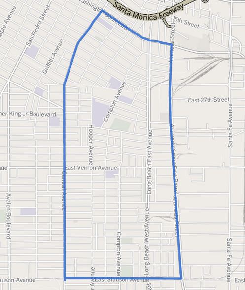
Map of Central Alameda, Los Angeles, CA, USA
Central-Alameda tops the list of Los Angeles city neighborhoods where adults over age 25 failed to finish high school—75%.
Description
Central-Alameda, which measure 2.18 square miles, is bounded on the north and northeast by Downtown, on the east by the city of Vernon, on the south by Huntington Park and Florence-Firestone, and on the west by Historic South Central and South Park. The street boundaries are north, Washington Boulevard; south, Slauson Avenue; west, Central Avenue, and east, Alameda Street. Central-Alameda encompasses the area of the neighborhood traditionally known as Nevin.
Nearby communities
Relation of Central-Alameda to other communities, not necessarily contiguous:
Population
According to the U.S. census, the neighborhood's population in 2000 was 40,947, which amounted to 18,760 people per square mile, among the highest densities for the city of Los Angeles and among the highest densities for the county. In 2008 the L.A. Department of City Planning estimated the population at 43,638. The average household size was 4.3 people, considered high for both the city and the county. Renters occupied 70.2% of the housing units and owners inhabited the rest, 29.8%.
There were 1,980 families headed by single parents, 26.3% of the total, considered high for both the city and the county. The median age was 22, "young for the city and young for the county." The percentages of residents aged 10 through 34 were among the county's highest. The percentages of never married men and women were among the county's highest. Just 444 people, 1.8% of the neighborhood population, were veterans, low for both the city and the county.
The Los Angeles Times considered the neighborhood "not especially diverse," with Latinos measuring 84.6% of the population (high for the county), blacks 13.3% (also high for the county), whites 1% and Asians 0.7%.
The median household income of $31,559 (in 2008 dollars) was low for both the city and the county.
Government
As part of the city government, the neighborhood is represented by the Central-Alameda Neighborhood Council.
Education and recreation
In education, just 2.8% of the residents 25 and older had a four-year degree, considered low when compared to the city and the county as a whole. Seventy-five percent of residents in that age range had failed to complete high school, the highest percentage of any Los Angeles City neighborhood.
Jefferson High School is situated within Central-Alameda at 41st and Hooper streets.
City recreation facilities include: