
Country United States County Lake Time zone CST (UTC-6) Elevation 216 m Local time Tuesday 12:56 AM Area code 219 | State Indiana FIPS code 18-11062 Zip code 46303 Population 11,706 (2013) | |
 | ||
Weather 17°C, Wind S at 42 km/h, 80% Humidity Area 24.89 km² (21.29 km² Land / 3.6 km² Water) | ||
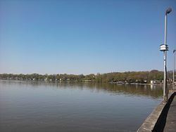
Fishing at cedar lake indiana by tomeperuser
Cedar Lake is a town in Hanover and Center townships, Lake County, Indiana, United States. The population was 11,560 at the 2010 census. The town is known for Cedar Lake (formerly Lake of the Red Cedars, Armour).
Contents
- Fishing at cedar lake indiana by tomeperuser
- Map of Cedar Lake IN USA
- Spring flick at crown point cedar lake indiana usa
- History
- Geography
- 2010 census
- 2000 census
- Education
- References
Map of Cedar Lake, IN, USA
Spring flick at crown point cedar lake indiana usa
History
Cedar Lake was settled by pioneers in the mid-19th century and originally named West Point. In 1839, it competed with the settlements of Liverpool and Lake Court House (later called Crown Point) to be the county seat of Lake County, but lost out to Liverpool. By 1870, the Cedar Lake Post Office was established, giving the area a new name. After the Monon Railroad came to the lake's western shore in 1882, many new residents flocked to the area along with tourists who saw the lake as a resort destination. From the late 19th century to the early 20th century, Cedar Lake was a popular place for Chicagoans looking for a retreat from the city. The lake had over 50 hotels at the time and several pavilions and ballrooms that brought many well-known bands to entertain the visitors.
The Lassen Hotel and Monon Park Dancing Pavilion are listed in the National Register of Historic Places.
Geography
Cedar Lake is located at 41°22′2″N 87°26′18″W (41.367234, -87.438326).
According to the 2010 census, Cedar Lake has a total area of 9.61 square miles (24.89 km2), of which 8.22 square miles (21.29 km2) (or 85.54%) is land and 1.39 square miles (3.60 km2) (or 14.46%) is water. The lake, which is the largest natural lake in northwest Indiana, appears to have formed from glacial meltwaters. There is an abundance of hills around the lake, which are evidence of the Valparaiso Moraine running through the area.
2010 census
As of the census of 2010, there were 11,560 people, 4,193 households, and 3,002 families residing in the town. The population density was 1,406.3 inhabitants per square mile (543.0/km2). There were 4,692 housing units at an average density of 570.8 per square mile (220.4/km2). The racial makeup of the town was 94.9% White, 0.5% African American, 0.3% Native American, 0.4% Asian, 2.4% from other races, and 1.7% from two or more races. Hispanic or Latino of any race were 6.5% of the population.
There were 4,193 households of which 39.1% had children under the age of 18 living with them, 53.9% were married couples living together, 11.7% had a female householder with no husband present, 6.0% had a male householder with no wife present, and 28.4% were non-families. 22.1% of all households were made up of individuals and 5.9% had someone living alone who was 65 years of age or older. The average household size was 2.75 and the average family size was 3.23.
The median age in the town was 34.9 years. 26.6% of residents were under the age of 18; 8.7% were between the ages of 18 and 24; 29.3% were from 25 to 44; 26.6% were from 45 to 64; and 8.6% were 65 years of age or older. The gender makeup of the town was 50.7% male and 49.3% female.
2000 census
As of the census of 2000, there were 9,279 people, 3,394 households, and 2,450 families residing in the town. The population density was 1,366.3 people per square mile (527.6/km²). There were 3,681 housing units at an average density of 542.0 per square mile (209.3/km²). The racial makeup of the town was 97.40% White, 0.09% African American, 0.24% Native American, 0.20% Asian, 0.88% from other races, and 1.19% from two or more races. Hispanic or Latino of any race were 3.50% of the population.
There were 3,394 households out of which 37.9% had children under the age of 18 living with them, 57.9% were married couples living together, 10.2% had a female householder with no husband present, and 27.8% were non-families. 22.5% of all households were made up of individuals and 7.0% had someone living alone who was 65 years of age or older. The average household size was 2.73 and the average family size was 3.23.
In the town, the population was spread out with 28.5% under the age of 18, 9.2% from 18 to 24, 32.9% from 25 to 44, 20.6% from 45 to 64, and 8.8% who were 65 years of age or older. The median age was 34 years. For every 100 females there were 104.0 males. For every 100 females age 18 and over, there were 102.3 males.
The median income for a household in the town was $43,987, and the median income for a family was $50,431. Males had a median income of $41,825 versus $24,861 for females. The per capita income for the town was $17,825. About 4.0% of families and 6.6% of the population were below the poverty line, including 6.7% of those under age 18 and 7.4% of those age 65 or over.
Education
Lake County Public Library operates the Cedar Lake Library at 10010 West 133rd Avenue.
Cedar Lake is home to the Hanover Community School Corporation. The corporation operates two elementary schools: Lincoln and Jane Ball, one middle school: Hanover Central Middle School, and one high school: Hanover Central High School.