
Type Artificial Max. length 7.5 km (4.7 mi) Surface elevation 1,143 m Length 7.5 km Province Province of Cosenza | Basin countries Italy Surface area 12.6 km (4.9 sq mi) Area 12.6 km² Catchment area 154.5 km² | |
 | ||
Water volume 108 hm (88,000 acre·ft) | ||
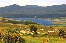
Cecita lake and s lorenzo church camigliatello silano cs
Cecita Lake (Italian: Lago di Cecita) is a lake in the province of Cosenza, Calabria, southern Italy. It is located in the northern part of the La Sila range on the western border of Sila National Park. The Mucone flows into and out of the lake. The lake is a reservoir built in 1951 by damming the Mucone. The dam is 55 meters high. Its purpose is to generate hydroelectricity. The dam is also used to irrigate surrounding fields which are largely used to grow potatoes. South of the lake is Lago di Ariamacina and Botte Donato.
Contents
- Cecita lake and s lorenzo church camigliatello silano cs
- Map of Cecita Lake Province of Cosenza Italy
- Moto guzzi 65c in the sila national park cecita lake
- References
Map of Cecita Lake, Province of Cosenza, Italy
Moto guzzi 65c in the sila national park cecita lake
References
Cecita Lake Wikipedia(Text) CC BY-SA