
Surface area 142 acres (57 ha) Surface elevation 1,737 m Mean depth 20 m | Basin countries United States Average depth 65 ft (20 m) Area 57 ha | |
 | ||
Primary inflows Primary outflows South Fork of the Ogden River | ||
Causey Reservoir is a reservoir located 15 miles (24 km) northeast of Ogden, Utah, United States just off Utah State Route 39.
Contents
Map of Causey Reservoir, Utah 84317, USA
GeographyEdit
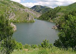
Causey is a 142-acre (0.57 km2) surface area reservoir on the South Fork of the Ogden River. It is a feature of the Weber Basin Project, and lies at an elevation of about 5,700 feet (1,700 m). The reservoir has a maximum depth of 182 feet (55 m) and a mean depth of 65 feet (20 m).
Causey is located in steep, forested, valley terrain, and extends into three canyons.
Management for the reservoir is under jurisdiction of the U.S. Forest Service, Wasatch-Cache National Forest.
HistoryEdit
Causey Dam was constructed between 1962 and 1966 by the Bureau of Reclamation to provide water to the northern Wasatch front area of Utah. It is an earthfill dam.
ActivitiesEdit
Activities at Causey Reservoir include boating and fishing. There are no dedicated boat-launch facilities, and only wake-less speeds are allowed. Fishing includes several trout varieties, including rainbow, cutthroat, and brown.
Swimming and cliff-jumping are also popular.
Camping and picnic sites are available at nearby Memorial Park, and along the Ogden River.
Camp Kiesel, a Boy Scout camp, is located on the northern arm of the reservoir.