
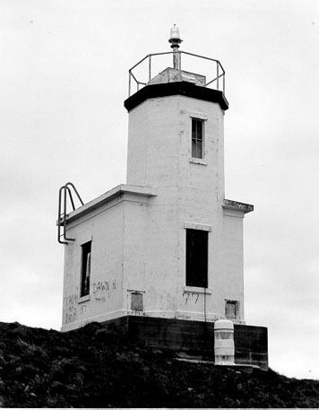
Foundation Surface Height 10 m Construction Concrete | Tower shape Octagonal Opened 1935 Material Concrete | |
 | ||
Year first lit 1888 (current tower 1935) Similar Lime Kiln Point State Park, Lime Kiln Light, Patos Island Light, Turn Point Light, Burrows Island Light | ||
Cattle Point Lighthouse is a lighthouse on the southeastern tip of San Juan Island overlooking the Strait of Juan de Fuca where the Haro Straits meet the San Juan Channel, in San Juan County, Washington. The light lies adjacent to the state's Cattle Point Natural Resources Conservation Area and, as of 2013, is part of the San Juan Islands National Monument.
Contents
Map of Cattle Point Lighthouse, Cattle Point Rd, Friday Harbor, WA 98250, USA
History
The first light at Cattle Point was a lens lantern on a post erected in 1888. In 1921, the U.S. Navy installed a radio compass station. The modern 34-foot (10 m), octagonal, concrete tower on Cattle Point was erected in 1935. Following automation in the late 1950s, the tower's lantern was removed and replaced with a 250-mm drum lens that sits on a short mast on top of the tower. The lighthouse received a temporary makeover in 1984, when it was used as a backdrop for an Exxon television commercial. The commercial's ahistorical additions were subsequently removed. The Coast Guard announced plans to reinforce the structure, which was in danger of collapse from the forces of erosion, during the summer of 2010.