
- elevation 2,000 m (6,562 ft) Length 500 km | Basin area 22,317 km² Basin area 22,317 km² | |
 | ||
The Catatumbo River (Spanish: Río Catatumbo) is a river rising in northern Colombia, flowing into Lake Maracaibo in Venezuela. The Catatumbo River is approximately 340 kilometres (210 mi) long. It forms a part of the international boundary between the two countries.
Contents
Map of Catatumbo River
Together with the nearby Río Escalante, Catatumbo is a producing area for cocoa beans of the Criollo cultivar.
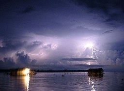
Catatumbo lightning
The "Relámpago del Catatumbo" or "Faros del Catatumbo" (Catatumbo lightning) is a phenomenon that occurs over the marshlands at the Lake Maracaibo mouth of the river, where lightning storms occur for about 10 hours a night, 140 to 160 nights a year, for a total of about 1.2 million lightning discharges per year. The light from this storm activity can be seen up to 40 kilometres (25 mi) away and has been used for ship navigation; it is also known as the "Maracaibo Beacon" for this reason.