
Canton Castelnau-de-Montmiral Area 88.81 km² | Region Occitanie | |
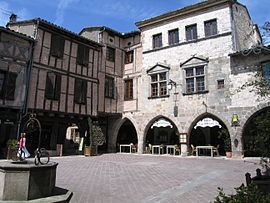 | ||
St antonin noble val penne bruniquel puycelsi castelnau de montmiral
Castelnau-de-Montmiral is a commune in the Tarn department in southern France.
Contents
- St antonin noble val penne bruniquel puycelsi castelnau de montmiral
- Map of 81140 Castelnau de Montmiral France
- Geography
- History
- Remarkable sites and monuments
- References
Map of 81140 Castelnau-de-Montmiral, France
Geography
The Vère flows westward through the commune.
History
While traces of activities dating back to the Bronze Age such as dolmens and oppidums can be seen in the nearby forest La Grésigne, the village was founded as an albigensian bastide in 1222 by Raymond VII, count of Toulouse, under the name “Castellum Novum Montis Mirabilis”.
During the subsequent years, the village remained an impressive stronghold. In 1345, during the Hundred Years' War, when Edward the Black Prince invaded the Albigeois, he reportedly left without besieging the village… Later, it served as a shelter for Catholics who were fleeing from Gaillac because of the Wars of Religion. King Louis XIII visited Castelnau in June 1622, and stayed in the “Tonnac” house.
Remarkable sites and monuments
Remarkable sites and monuments in Castelnau-de-Montmiral include :