
Elevation 195 m (640 ft) Time zone CET (UTC+1) Local time Monday 4:20 AM Postal code 48010 Dialling code 0546 | Demonym(s) Casolani Area 84.4 km² | |
 | ||
Frazioni Baffadi, Mercatale, Prugno, Sant'Apollinare, Valsenio, Zattaglia Weather 10°C, Wind SW at 23 km/h, 74% Humidity | ||
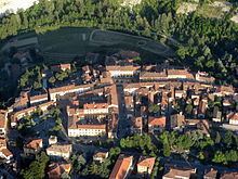
Casola Valsenio is a comune (municipality) in the Province of Ravenna in the Italian region Emilia-Romagna, located about 60 kilometres (37 mi) southeast of Bologna and about 60 kilometres (37 mi) southwest of Ravenna.
Contents
Map of 48032 Casola Valsenio Province of Ravenna, Italy
History
The village was founded in 1216 after the destruction of the Casola castle by the troops of Faenza. Later it was a possession of the Pagani, Visconti, Manfredi, Riario families and of Cesare Borgia.
Main sights
References
Casola Valsenio Wikipedia(Text) CC BY-SA