
Country United States County Cumberland Time zone Eastern (EST) (UTC-5) Elevation 166 m Population 3,742 (2010) | Incorporated 1841 Area code(s) 207 Zip code 04015 Local time Sunday 8:06 PM | |
 | ||
Weather -8°C, Wind NW at 18 km/h, 32% Humidity | ||
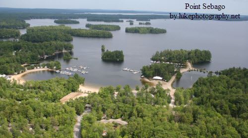
Casco is a town in Cumberland County, Maine, United States. The population was 3,742 at the 2010 census. Casco includes the villages of Casco, South Casco and Cook Mills. The town borders the east shore of Sebago Lake, and is home to part of Sebago Lake State Park. Casco is part of the Portland–South Portland–Biddeford, Maine metropolitan statistical area. Casco is just under 30 miles (48 km) from downtown Portland.
Contents
- Map of Casco ME USA
- History
- Geography
- 2010 census
- 2000 census
- Transportation
- Sites of interest
- Notable people
- References
Map of Casco, ME, USA
Casco is the home of "Casco Days", an annual community fair which takes place in Casco Days Park, always on the last Saturday in July.
History
On January 30, 1767, Raymondtown Plantation was granted by the Massachusetts General Court to Capt. William Raymond of Beverly, Massachusetts and his company of soldiers for their service with Sir William Phipps in the 1690 Battle of Quebec. It replaced a 1735 grant called Beverly-Canada (now Weare, New Hampshire) which was ruled invalid in 1741 because of a prior claim by the heirs of John Mason. In 1803, Raymondtown Plantation was incorporated as Raymond. The town of Naples was created with land taken in 1838, the same year the western half of Raymond petitioned the legislature to be set off as a township because of its geographical separation behind Rattlesnake Mountain. The petition failed, but three years later another was accepted. On March 18, 1841, Casco was incorporated as a town.
Farmers found the surface of the town uneven, its hard and rocky soil "tolerably productive." Outlets of ponds, however, provided Casco with good sites for water powered mills. The town had four sawmills, four gristmills, a shook mill, a barrel stave mill, four shingle factories, a carriage factory and a tannery. In 1832, the Cumberland and Oxford Canal made Sebago Lake a direct trade route to Portland. Steamboat travel commenced on the waterways in the 1840s, carrying tourists and freight. In 1938, Sebago Lake State Park was established, one of the state's five original state parks.
Geography
According to the United States Census Bureau, the town has a total area of 38.01 square miles (98.45 km2), of which 31.24 square miles (80.91 km2) is land and 6.77 square miles (17.53 km2) is water. Casco is drained by the Crooked River and Songo River.
The town is crossed by U.S. Route 302 and state routes 11, 85 and 121. It is bordered by the town of Raymond to the southeast, Naples and Otisfield to the northwest, and Poland to the northeast. The village of Casco, a census-designated place, is located along Route 121 near the northern corner of town. South Casco is located along US 302 between Sebago Lake and Thomas Pond in the southeast corner of the town, and Cook Mills is located along Route 11 near the western border of the town.
2010 census
As of the census of 2010, there were 3,742 people, 1,554 households, and 1,041 families residing in the town. The population density was 119.8 inhabitants per square mile (46.3/km2). There were 2,944 housing units at an average density of 94.2 per square mile (36.4/km2). The racial makeup of the town was 97.0% White, 0.7% African American, 0.3% Native American, 0.3% Asian, 0.2% from other races, and 1.5% from two or more races. Hispanic or Latino of any race were 1.2% of the population.
There were 1,554 households of which 29.7% had children under the age of 18 living with them, 51.4% were married couples living together, 10.6% had a female householder with no husband present, 5.0% had a male householder with no wife present, and 33.0% were non-families. 25.0% of all households were made up of individuals and 11.5% had someone living alone who was 65 years of age or older. The average household size was 2.41 and the average family size was 2.82.
The median age in the town was 42.6 years. 21.5% of residents were under the age of 18; 6.3% were between the ages of 18 and 24; 25.9% were from 25 to 44; 31.8% were from 45 to 64; and 14.7% were 65 years of age or older. The gender makeup of the town was 49.4% male and 50.6% female.
2000 census
As of the census of 2000, there were 3,469 people, 1,327 households, and 958 families residing in the town. The population density was 110.9 people per square mile (42.8/km²). There were 1,958 housing units at an average density of 62.6 per square mile (24.2/km²). The racial makeup of the town was 97.95% White, 0.29% African American, 0.37% Native American, 0.52% Asian, 0.12% from other races, and 0.75% from two or more races. Hispanic or Latino of any race were 0.52% of the population.
There were 1,327 households out of which 34.1% had children under the age of 18 living with them, 58.3% were married couples living together, 10.4% had a female householder with no husband present, and 27.8% were non-families. 20.4% of all households were made up of individuals and 6.8% had someone living alone who was 65 years of age or older. The average household size was 2.58 and the average family size was 2.96.
In the town, the population was spread out with 25.2% under the age of 18, 6.5% from 18 to 24, 32.1% from 25 to 44, 24.7% from 45 to 64, and 11.4% who were 65 years of age or older. The median age was 38 years. For every 100 females there were 97.7 males. For every 100 females age 18 and over, there were 94.3 males.
The median income for a household in the town was $41,629, and the median income for a family was $49,500. Males had a median income of $31,679 versus $25,306 for females. The per capita income for the town was $19,306. About 5.3% of families and 8.1% of the population were below the poverty line, including 8.5% of those under age 18 and 9.8% of those age 65 or over.
Transportation
Casco is home to several important roads, both locally and nationally.