
OS grid reference SD9801 Sovereign state United Kingdom | Post town STALYBRIDGE Dialling code 01457 | |
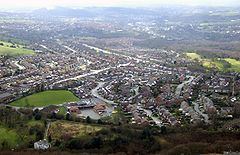 | ||
Carrbrook is an area in the east of Stalybridge, in Greater Manchester, England. The area still has many seventeenth and eighteenth century buildings. Much of the late-nineteenth and early-twentieth century village was built during the industrial boom brought by the printworks. Modern Housing estates were built next to the old village on the lower flank of Harridge Pike from the 1970s. The view to the east of Carrbrook is dominated by the steep-sided Buckton Hill, on the summit of which is located Buckton Castle. Neighbouring communities include Millbrook, Heyheads and Micklehurst.
Contents
Map of Carrbrook, Stalybridge, UK
Music
Every year on Whit Friday, Carrbrook is host to a very lively and popular Brass Band Contest outside the Buckton Vale Institute in Carrbrook Village.
References
Carrbrook Wikipedia(Text) CC BY-SA