
Phone +33 2 97 52 29 81 | ||
 | ||
Hours Closed now Saturday10AM–5PMSunday10AM–5PMMonday10AM–5PMTuesday10AM–5PMWednesday10AM–5PMThursday10AM–5PMFriday10AM–5PM Similar Locmariaquer megaliths, Musée de préhistoire à Carnac, Gavrinis, Table des Marchand, Église Saint‑Cornély de Carnac Profiles | ||
Carnac stones
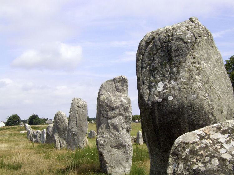
The Carnac stones (Breton: Steudadoù Karnag) are an exceptionally dense collection of megalithic sites around the village of Carnac in Brittany, consisting of alignments, dolmens, tumuli and single menhirs. More than 3,000 prehistoric standing stones were hewn from local rock and erected by the pre/proto-Celtic people of Brittany, and form the largest such collection in the world. Most of the stones are within the Breton village of Carnac, but some to the east are within La Trinité-sur-Mer. The stones were erected at some stage during the Neolithic period, probably around 3300 BCE, but some may date to as early as 4500 BCE.
Contents
- Carnac stones
- Unexplained structures carnac stones
- Alignments
- Mnec alignments
- Kermario alignment
- Kerlescan alignments
- Petit Mnec alignments
- Tumuli
- Dolmens
- Other formations
- Excavation and analysis
- Miln and Le Rouzic
- Other theories
- Management
- References
Although the stones date from 4500 BCE, modern myths were formed which resulted from 1st century AD Roman and later Christian occupations, such as Saint Cornelius a Christian myth associated with the stones held that they were pagan soldiers in pursuit of Pope Cornelius when he turned them to stone. Brittany has its own local versions of the Arthurian cycle. Local tradition claims that the reason they stand in such perfectly straight lines is that they are a Roman legion turned to stone by Merlin.
In recent centuries, many of the sites have been neglected, with reports of dolmens being used as sheep shelters, chicken sheds or even ovens. Even more commonly, stones have been removed to make way for roads, or as building materials. The continuing management of the sites remains a controversial topic.
Unexplained structures carnac stones
Alignments
There are three major groups of stone rows — Ménec, Kermario and Kerlescan — which may have once formed a single group, but have been split up as stones were removed for other purposes.
Ménec alignments
Eleven converging rows of menhirs stretching for 1,165 by 100 metres (3,822 by 328 feet). There are what Alexander Thom considered to be the remains of stone circles at either end. According to the tourist office there is a "cromlech containing 71 stone blocks" at the western end and a very ruined cromlech at the eastern end. The largest stones, around 4 metres (13 feet) high, are at the wider, western end; the stones then become as small as 0.6 metres (2 feet 0 inches) high along the length of the alignment before growing in height again toward the extreme eastern end.
Kermario alignment
This fan-like layout recurs a little further along to the east in the Kermario (House of the Dead) alignment. It consists of 1029 stones in ten columns, about 1,300 m (4,300 ft) in length. A stone circle to the east end, where the stones are shorter, was revealed by aerial photography.
Kerlescan alignments
A smaller group of 555 stones, further to the east of the other two sites. It is composed of 13 lines with a total length of about 800 metres (2,600 ft), ranging in height from 80 cm (2 ft 7 in) to 4 m (13 ft). At the extreme west, where the stones are tallest, there is a stone circle which has 39 stones. There may also be another stone circle to the north.
Petit-Ménec alignments
A much smaller group, further east again of Kerlescan, falling within the commune of La Trinité-sur-Mer. These are now set in woods, and most are covered with moss and ivy.
Tumuli
There are several tumuli, mounds of earth built up over a grave. In this area, they generally feature a passage leading to a central chamber which once held neolithic artefacts.
Also known as Er Mané, it is a chamber tomb 85 m (279 ft) long, 35 m (115 ft) wide, and 5 m (16 ft) high. It has a dolmen at the west end, and two tombs at the east end. A small menhir, approximately 3 m (10 ft) high, is nearby.
Dolmens
There are several dolmens scattered around the area. These dolmens are generally considered to have been tombs; however, the acidic soil of Brittany has eroded away the bones. They were constructed with several large stones supporting a capstone, then buried under a mound of earth. In many cases, the mound is no longer present, sometimes due to archeological excavation, and only the large stones remain, in various states of ruin.
Other formations
There are some individual menhirs and at least one other formation which do not fit into the above categories.
Near the quadrilateral is a single massive menhir, now known as the "Giant". Over 6.5 m (21 ft) tall, it was re-erected around 1900 by Zacharie Le Rouzic, and overlooks the nearby Kerlescan alignment.
Excavation and analysis
From the 1720s increasing interest was shown in these features. In 1796, for example, La Tour d'Auvergne attributed them to druidic gatherings. In 1805, A. Maudet de Penhoët claimed they represented stars in the sky.
Englishmen Francis Ronalds and Alexander Blair made a detailed survey of the stones in 1834. Ronalds created the first accurate drawings of many of them with his patented perspective tracing instrument, which were printed in a book Sketches at Carnac (Brittany) in 1834.
Miln and Le Rouzic
The first extensive excavation was performed in the 1860s by Scottish antiquary James Miln (1819–1881), who reported that by then fewer than 700 of the 3,000 stones were still standing. Towards 1875, Miln engaged a local boy, Zacharie Le Rouzic (1864–1939), as his assistant, and Zacharie learnt archaeology on the job. After Miln's death, he left the results of his excavations to the town of Carnac, and the James Miln Museum was established there by his brother Robert to house the artefacts. Zacharie became the director of the Museum and, although self-taught, became an internationally recognised expert on megaliths in the region. He too left the results of his work to the town, and the museum is now named Le Musée de Préhistoire James Miln – Zacharie le Rouzic.
Other theories
In 1887, H. de Cleuziou argued for a connection between the rows of stones and the directions of sunsets at the solstices.
Among more recent studies, Alexander Thom worked with his son Archie from 1970 to 1974 to carry out a detailed survey of the Carnac alignments, and produced a series of papers on the astronomical alignments of the stones as well as statistical analysis supporting his concept of the megalithic yard. Thom's megalithic yard has been challenged.
There are also general theories on the use of the stones as astronomical observatories, as has been claimed for Stonehenge. According to one such theory, the massive menhir at nearby Locmariaquer was linked to the alignments for such a purpose.
Management
The Musée de Préhistoire James Miln – Zacharie le Rouzic is at the centre of conserving and displaying the artefacts from the area. It also contains the "world's largest collection [of] prehistoric[al] exhibits" with over 6,600 prehistoric objects from 136 different sites.
The monuments themselves were listed and purchased by the State at the start of the 20th century to protect them against quarrymen, and while this was successful at the time, in the mid century redevelopment, changes to agricultural practices and increasing tourism bringing visitors to the stones led to rapid deterioration. The Ministère de la Culture et de la Communication (Heritage Ministry) re-examined the issue from 1984, and subsequently set up the ‘Mission Carnac’ 1991 with the aim of rehabilitating and developing the alignments. This involved restricting public access, launching a series of scientific and technical studies, and producing a plan for conservation and development in the area.
As with the megalithic structure of Stonehenge in England, management of the stones can be controversial. Since 1991, the main groups of stone rows have been protected from the public by fences "to help vegetation growth", preventing visits except by organised tours. They are open during Winter, however. When James Miln studied the stones in the 1860s, he reported that fewer than 700 of the 3,000 stones were still standing, and subsequent work during the 1930s and 1980s (using bulldozers) rearranged the stones, re-erecting some, to make way for roads or other structures. In 2002, protesters invaded the site, opening the padlocks and allowing tourists free entry. In particular, the group Collectif Holl a gevred (French and Breton for "the everyone-together collective") occupied the visitor centre for the Kermario alignment, demanding an immediate stop to current management plans and local input into further plans.
In recent years, management of the site has also experimented with allowing sheep to graze among the stones, in order to keep gorse and other weeds under control.