
Founded 16th century Barangays Local time Friday 11:42 PM University STI College - Southwoods | Incorporated February 20, 1857 Area 40.24 km² | |
 | ||
Weather 25°C, Wind E at 0 km/h, 87% Humidity Similar Cavite, Dasmariñas, Tagaytay Established February 20, 1857 Cityhood July 8, 2023 Named for Carmona, Seville, Spain Mayor Dahlia A. Loyola Vice Mayor Cesar L. Ines, Jr. Representative Roy M. Loyola Electorate 58,691 voters (2023) Total area 29.68 km2 (11.46 sq mi) Elevation 112.13 m (367.88 ft) Highest elevation 212.96 m (698.69 ft) Lowest elevation 11.3 m (37.1 ft) Total Population (2020 census) 106,256 Population Density 3,600/km2 (9,300/sq mi) Households Population 28,154 Demonyms Carmonian (English); Carmonense, Taga-Carmona (Filipino) Service provider (Electricity) Manila Electric Company (Meralco) Time zone UTC+8 (PST) ZIP code 4116 PSGC 042104000 IDD : area code +63 (0)46 Native languages Tagalog Website carmonagov.net | ||
House and home oakwood b house turned over carmona cavite phil
Carmona (Filipino: Bayan ng Carmona) is a first class urban municipality in the province of Cavite, Philippines. According to the 2015 census, it has a population of 97,557 people.
Contents
- House and home oakwood b house turned over carmona cavite phil
- Map of Carmona Cavite Philippines
- Geography
- Land area
- Topography
- Slope
- Water resources
- Elevation
- Fault line
- Climate
- Soil properties
- Mineral resources
- Demographics
- Population density
- Population distribution
- Language
- Religion
- Registered voters
- History
- Timeline of Carmona
- Former municipal mayors
- Barangays
- Poblacion
- Barrios
- Sitio
- Landmarks
- Religious and historical sites
- Natural attractions
- Sports attractions
- Recreational attractions
- Eco tourism
- Resorts
- Other attractions
- Economy
- Agriculture
- Industry
- Business
- Commercial and financial
- Festivals
- Parish church
- Education
- Transportation
- Housing
- Health services
- Peace and order
- Environmental management
- Notable people
- City twinning
- References
Map of Carmona, Cavite, Philippines
Geography
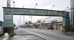
Carmona is located on the south-eastern part of the province of Cavite, approximately 36 kilometres (22 mi) south of Manila and 24 kilometres (15 mi) from Trece Martires City, Cavite’s provincial capital. It is bounded on the north, east and south by the City of Biñan, Laguna, Municipality of General Mariano Alvarez (GMA) on the north-west and Silang on the south-west. The geographic coordinates of Carmona are about 14.32° latitude and 121.06° longitude.
Land area
With a total land area of 3,092 hectares or 30.92 square kilometers, Carmona represented 2.17% of the total land area of the province. These areas are currently occupied by 14 barangays of which 7 are considered Poblacion barangays and 7 others are regular barangays. Barangay Lantic is the largest area while Barangay 2 has the smallest area.
Topography
The topography of Carmona is generally flat to strongly rolling or sloping, partly lowland and partly hill. Carmona is divided into four physiographical areas: the lowest lowland area, the lowland area, the central hilly area and the upland mountainous area.
Slope
The first slope of the municipality is 0-3%; broad to level or nearly level is classified as under 0-3% slope. This is generally the flat plain level lands of the Barangay Maduya.
The second slope, ranging from 3 to 8%, is gently sloping areas with land sloping, gently undulating and rolling. This area comprises Poblacion 1 through 8, and also a portion of Cabilang Baybay with a small portion of Barangays Milagrosa and Mabuhay.
In the central area of the municipality is a slope ranging from 8 to 18%. This area comprises the rest of Barangay Milagrosa, a small portion of Barangay Cabilang Baybay and the middle portion of Barangay Mabuhay and Lantic.
And the last slope of municipality ranges from 15% to more than 40%. This area comprises the western part of Carmona including the Barangay Bancal and the rest of Barangay Mabuhay and Lantic.
Water resources
Inland water bodies serve as natural boundaries with neighboring municipalities and drain its surface waters towards Manila Bay and Laguna Bay. These are the San Gabriel River on the eastern boundaries with GMA, Cavite and Carmona River on the western boundaries with Biñan, Laguna.
The hydrological network of the town is composed of main rivers and tributaries. It also has springs, waterfalls and artesian wells. Deep wells provide water supply for both domestic and irrigation purposes.
Elevation
Carmona is an elevation of about 38 to 87 meters or 125 to 285 feet above sea level. The lowest elevation is Barangay Maduya, while the Poblacion Areas (Barangay 1–8), Barangay Cabilang Baybay, the northern part of Mabuhay, Milagrosa and Lantic are at an average elevation, the southern part of Milagrosa is situated at a higher elevation, and Barangay Bancal and the rest of Barangay Mabuhay and Lantic are situated at a very high elevation.
Fault line
Carmona is included in the Valley Fault System. The line of the Valley Fault System starts from the Sierra Madre and passes through in this town.
Climate
Carmona has a Type I climate characterized by two pronounced seasons: dry from November to April and wet during rest of the year. Maximum rainfall usually occurs from June to September. The average annual rainfall is 200 millimeters with a peak of 400 millimeters in August.
The average annual temperature is 27.2 C. The highest temperature occurs during the month of May while the lowest occurs during the month of January.
The predominant wind direction comes from the south-west during the month of June to September and from the north-west during the month of October to January, while from February to April, the wind is coming from the southeast, predominantly in the month of May.
The average humidity of Carmona is 81%. This makes the municipality cooler than the Metropolitan Manila Area where the average humidity is higher.
Soil properties
The eastern side of Cavite consists of Carmona clay loam with streaks of Carmona clay loam steep phase and Carmona sandy clay loam. This type of soil is granular with tuffaceous material and concretions. It is hard and compact when dry, sticky and plastic when wet. This type of soil is planted with rice with irrigation or sugarcane without irrigation. Fruit trees such as mango, avocado and citrus are also grown in this type of soil.
Mineral resources
Cavite coastal areas have marl and conglomerate sedimentary rocks and some igneous rocks which are prominent in the high, mountainous regions of the western part of the province. Carmona reserves and deposits of sand, clay and gravel materials are found in Sitio Ulong Tubig, Mabuhay.
Demographics
In the 2015 census, the population of Carmona, Cavite, was 97,557 people, with a density of 2,400 inhabitants per square kilometre or 6,200 inhabitants per square mile.
In the 2010 census, Carmona had a total population of 74,986 which represented a total number of households at 14,885.
Population density
The highest densities are found in the Poblacion area (Barangays 1–8) and Barangays Milagrosa and Maduya, where land areas are significantly lower than the other barangays. Barangay Lantic posted development of the Kuok Property within the Lantic area; it is expected that the density will increase within the ten-year period.
Population distribution
Carmona's population is concentrated in Barangays 1-8 at the Poblacion area. Brgy. Milagrosa is the most populated barangay, which posted a total population of 15,284. Dense population is also found in Brgy. 9, the central business district of the municipality. Most population catalysts such as banks, town center, and commercial establishments are found in the Poblacion area.
Language
The main language spoken is Tagalog. In some areas they speak Chabacano or Chavacano, sometimes referred to by linguists as Philippine Creole Spanish, a Spanish-based creole language spoken in the Philippines. English is considered as the second language and is widely used as medium of communication in business and higher education. Other Philippine languages spoken are Waray, Bicolano, Cebuano, Ilokano, Pangasinense, and Hiligaynon. Chinese and Spanish are also spoken by some local residents.
Religion
Roman Catholicism is a fast-growth church throughout Carmona. Iglesia ni Cristo, Baptist, Adventist, Jehovah's Witness, LDS Churches, Protestant/Christian churches, Islam, born again Christian fellowships (Jesus Is Lord, Victory, Word for the World, Community Harvest, Community of Praise, Jesus Christ Spreading the Good News, Lord's Vineyard Covenant Community etc.) and Members Church of God International (Ang Dating Daan) are also established in two Baranggay's.
Registered voters
There are 38,105 registered voters in Carmona (2009 COMELEC) out of a total Carmona population of 74,986 (as of the May 1, 2010 census).
History
Carmona was just a part of the big town of Silang. This is not surprising because in the early part of the Spanish regime Silang included what today are known as the municipalities of Indang: San Francisco de Malabon (now General Trias), and Maragondon. Moreover, Alfonso, Amadeo, and Mendez were mere sitios of Indang; Sta. Cruz de Malabon (now Tanza) was a part of San Francisco de Malabon or Malabon Grande; and Magallanes and Ternate were barrios of Maragondon. Furthermore, Maragondon itself had been a part of the Corregimiento of Mariveles on the opposite side of Manila Bay.
According to research conducted in 1982, by Sangguniang Bayan members Ernesto Zamora, Salvador P. Manahan, Pio Purificacion, Narciso Levardo, and Romy Laurito, assisted by Municipal Secretary Rogelio D. Paular, it was found out that the history of Carmona began during the 15th century. As related by a reliable informant, three brothers coming from the mountain of Silang were said to be the first settlers in the place which was then called “Latag”, a Tagalog word for “plain” due to the numerous hills and plains in the area. The settlement was not known to other residents of Silang until some of them also went down to the place, cleared some forest areas and established their residence.
In 1595, Silang became a town and Latag was annexed as a part since then. Latag gradually developed into a community whose residents struggled hard to make it a town. Their burning desires were filled with hopes and fulfillment in 1856 when their move for the conversion of Latag into a town was spearheaded by a leader named Tiburcio Purificacion. Finally, by virtue of a decree issued on February 20, 1857 by the King of Spain through Governor General Fernando de Norzagaray, Latag became a separate municipality with the name it bears today: Carmona, named after the town of Carmona in the province of Seville, Spain. Yet until now, it had not been known where the name originated.
During the Philippine Revolution in 1896, the gobernadorcillo of Carmona was Kapitan Damian Ermitano after the administrations of Tiburcio Purificacion, Mariano Mapanoo and Donald C. Virtucio, Augusto Manaog and Fabian Tenedero.
After the revolution and the occupation of the country by the Americans in 1901, the first local executive of Carmona was Martin Reyes who was followed next by Marcelo Reyes, Prudencio Torres, Juan Alumia, Estanislao Paular, Marciano Mapanoo, and Juan Zamora.
The mayors who assumed office after World War II were the following honorable men: Bernardo Hebron, Eulalio Reyes and Cesar Casal and Felino L. Maquinay. In 1959, the district of San Gabriel and San Jose of Barangay Kabilang Baybay was purchased by the National Government for the relocation of squatters from Metro Manila. On March 14, 1981, the relocation site, which teemed with people from almost every part of the country and was more popularly known as the resettlement area, became an independent municipality called General Mariano Alvarez.
Timeline of Carmona
Former municipal mayors
- Marcelino P. Clarito
- Marcelo Reyes
- Martin Reyes
- Prudencio Torres
- Marcelo Reyes (re-elected)
- Juan R. Alumia
- Estanislao G. Paular (1931–1937)
- Marciano Mapanoo (1938–1941)
- Candido G. Hebron (1942–1943)
- Juan Zamora (1943–1944)
- Alfredo Anulat (1944–1945)
- Arsenio Mapalad (1945–1946)
- Bernardo B. Hebron (1946–1955)
- Eulalio Reyes (1955–1956)
- Cesar E. Casal (1956–1979)
- Felino L. Maquinay (1980–1986)
- Estelito Torres (OIC, 1986–1988)
- Felino Maquinay (1988 – February 1990)
- Rolando Rosas (February 1990 – 1995)
- Roy M. Loyola (1995–2004; 2007–2010)
- Dahlia A. Loyola (2004–2007; 2010–present)
Barangays
Carmona is politically subdivided into 14 barangays. Eight of the current barangays are classified as poblacion barangays and the six others are ordinary barangays or barrios.
Poblacion
Eight of the current barangays are classified as poblacion barangays, or those that are within the municipality's central area:
Barrios
Six of the current barangays are classified as ordinary barangays or barrios, those that have a civilization of their own and well-organized independent villages.
Sitio
A sitio is a territorial enclave that forms part of a barangay, the location of which may be distant from the center of the barangay itself. Only partial knowledge is available about the sitios of Carmona, but patiently researching some information revealed the following:
Landmarks
Here are some of Carmona's landmarks:
Religious and historical sites
The people of Carmona actively participated in the revolution against the Spaniards. Carmona also witnessed the Filipinos’ resistance against the Japanese forces. During the Japanese occupation, some of Carmona’s prominent houses were used as Japanese headquarters while the hills became the stronghold of Filipino revolutionaries.
Like other towns, Carmona also has historical sites and buildings related to wars. Only a few were during the Spanish period. Most of the historical events were during World War II.
Natural attractions
Sports attractions
Recreational attractions
Eco-tourism
Resorts
Other attractions
Economy
Cottage industries include metal works, metalcraft, footwear industries, concrete products, tricycle assembly, rattan handicrafts and bakeries. Manufacturing firms engaged in handicraft (bags and shoes), furniture making, business retailing, personal and business services, and food based enterprises contribute to the municipality’s trade and commerce. Mercantile activities in the municipality are concentrated at the Poblacion area and along Governor’s Drive. Carmona has been classified as a first class municipality since July 1996, brought about by industrialization, real estate development and commercial activities.
Carmona’s progress accelerated after the conversion of more than fifty hectares of farmlands into industrial areas in 1998. Garment industries, steel fabrication, microchips and semi-conductors, tool fabrication, bus assembly, bulb factories, die casting and other small and medium-scale industries currently operate in the municipality. These investments continue to provide local employment, generate export earnings, increase municipal revenues and serve as vehicles for technology transfer. Foreign investments are pouring in as export-oriented industries continue to flourish.
Employment rate: Out of a potential labor force of 24,918 (members 15 years old & above who are actively seeking for work), 98.03% are employed while 1.97% are unemployed. The presence of 8 industrial estates & 2 industrial compounds contribute largely to the high employment rate of the municipality.
Agriculture
The economy of Carmona is generally agricultural. Almost half of its total land area is devoted to agriculture.
In 2000, the total land area devoted to agriculture was 609 or roughly 19.60% of the total land area of Carmona, which is 3,902 hectares. 230 hectares are irrigated areas all of which are currently planted with rice and vegetables, 30 hectares are upland rice areas, 122.5 hectares are for diversified trees and crops, and the other 211.5 hectares are considered pasture land.
There are 217 farmers in the Municipality engaged in planting and farming. Crops and livestock farmers are distributed among 14 barangays of Carmona.
However, with the implementation of the CALABARZON growth area, the municipality of Carmona has slowly become an industrial enclave in the province. The advent of industrialization has threatened the agricultural base of Carmona. As of April 1999, land used for rice production has gone down; sugarcane plantation has decreased considerably and those land uses for other crops and vegetables totaled 84.5 hectares during the same year.
At present, the programs and services of the Department of Agriculture (DA) are focused on five priority programs: a sustained self-sufficiency program for rice and corn, strengthening of production market linkage, an acceleration of livelihood program, aggressive assistance to organizational development of farmers, and assistance to agriculture-related priority programs of other government agencies.
Industry
Industrialization in the '90s accounts for the rapid growth of Carmona's business community from an otherwise quaint agricultural town in the 1950s. Brought about by huge capital from the national government, the industrial complexes bolstered the increase of the municipality's revenues and the change in the people's lifestyle.
There are eight existing industrial complexes in the towns. Its proximity to Manila and at the same time being the gateway to the Calabarzon area made Carmona a promising venue for business.
On the other hand, the local government has been very supportive of the investors. There are 114 factories in eight industrial parks/complexes to date. At present there are the eight industrial complexes strewn along the Governor's Drive, in a total of 419.31 hectares, making up 13.56% of the town's land area. Ranging from 9 to 100 hectares, these industrial estates are complete with amenities, secured, and in close coordination with the municipal government through the Carmona Business Club and other agencies.
Business
Carmona is composed of 975 commercial and business establishments. One is the Walter Mart Commercial Center situated at the Macaria Business Park which covers a land area of 13.13 ha.
Over 1100 duly registered commercial and financial establishments conduct trading, banking, servicing, settlements, recreation and entertainment.
Commercial and financial
One of the biggest commercial subdivisions in town is the Macaria Business Park in Barangay Mabuhay which houses Waltermart in its 13.13 hectare lot. Recently, fastfood chains and restaurants have been opened to compete for regular patronage at the Paseo de Carmona in Barangay Maduya.
Moreover, numerous traders and retailers are housed in the bustling Carmona Public Market.
The bulk of commercial activities come from wholesale/retail enterprises, which comprise a total of 619 establishments. There are also service-related establishments: businesses, food shops and amusement operators, with 35 banks and other lending institutions. Among the major banking institutions that cater to the financial needs of businesses in Carmona and neighboring towns are Bank of Philippine Islands (BPI), Metrobank, Banco de Oro (BDO), Chinatrust Bank, China Bank, RCBC, and Union Bank.
Festivals
Carmona is the only municipality in the Philippines that observes a triennial draw of its communal lands among its locals – a practice that dates back to the country's Spanish colonization period. It is celebrated every 3 years from February 16 to 22.
After the war, Carmona started to find its path towards economic and political stabilization. During this period, the provision of a stable means of livelihood for all the people became top priority. Since Carmona was basically agricultural, the communal agricultural lands were offered to the farmers for cultivation through a lottery. This practice, held every three years, was locally known as "sorteo". Since then, "sorteo" has been embedded into the municipality's traditional procedures on land ownership. To this day, farm lots are being raffled off to interested farmers; lucky winners are awarded the right to till and develop a certain section of the communal lands. The traditional practice of "sorteo" defuses agrarian unrest and decreases tensions on land conflicts.
An age-old tradition celebrating the town as an agricultural haven is celebrated every 3 years. It is highlighted by an agro-industrial fair.
Sorteo events:
Parish church
Saint Joseph, the spouse of Mary, has been one of the most popular patron saints in Cavite. This is attested by the fact that four parishes and numerous barangays of Cavite are dedicated to him.
Carmona was the first parish in Cavite to have been dedicated to St. Joseph. Originally, Carmona was a barrio of Silang. Its old name was Latag, a Tagalog word which means “plain.” The town (its barrios before) constituted a vast expanse of leveled land. This plain was cleared by settlers and became mostly rice fields. As a barrio, it was civilly and ecclesiastically under Silang.
Silang got into a conflict with the hacienda administrator of the Dominican Hacienda of Biñan. In this dispute, it seemed that the local leaders of Silang conducted themselves with great propriety and dignity. The Spanish government recognized this effort. So pleased was the King of Spain that when this honorable people sent a petition to the King, the latter did not hesitate to grant their request. On April 14, 1746, King Ferdinand VI issued a royal decree selling the land that was part of Silang comprising the barrio of Latag to the local principalia. Latag was acquired for the amount of two thousand Mexican pesos. Don Pedro Calderon (the oidor) and Don Alejo Aviles (the escribano (notary)) signed the document of sale in the King’s behalf while Don Bernabe Javier Manalo and Don Gervacio dela Cruz signed on behalf of the people of Silang. From that time on, a big portion of Latag became communal land where people could take turns in farming. It was a unique privilege given to them.
The Franciscans were the first to evangelize Silang and its neighboring towns like Indang and Maragondon. It is then safe to say that Latag may have been ministered to by the Franciscans, as well. However, in 1599, the Jesuits took over the administration of the parish in Silang. They became ardent propagators of the Christian faith. They went to the different parts of upland Cavite, building churches and teaching the faith. It was customary then that the Spanish religious priests concentrated their efforts in the poblacion. It was also customary practice to get Filipino secular clerics who would serve as assistants. They were usually sent to more difficult areas of the parish, usually far from where the center was. Although the road connecting Latag and Silang was bad, they said masses for the natives and baptized these natives’ children. The Filipino priest B. D. Eulogio Fabian is believed to have ministered to the people.
On February 20, 1857, the King of Spain through Governor General Don Fernando de Norzagaray created the new town of Carmona. Latag was renamed Carmona after the town in Seville, Spain.
By 1854, the administration of Silang was handed over to the Spanish Recollect friars. Imus and Dasmariñas were then haciendas owned by the Recollects and were under their spiritual care. From 1768 to 1857, the Filipino priest Eulogio Fabian took care of Latag. On December 15, 1857, the new town of Carmona became an independent parish with St. Joseph as its patron. Fr. Ramon Zueco de San Joaquin became its first Recollect parish priest. The Jesuits who were the former evangelizers must have been influential in choosing St. Joseph as patron of the new town and Our Lady of the Holy Rosary became its second patroness. A church made of stone and a massive convent was built.
Education
The education sector in Carmona improved in many aspects of endeavor. In line with the local government's thrust of enhancing quality education, the Department of Education (DepEd), particularly the District of Carmona and Carmona National High School, with the full support of the local government unit, implemented various programs and projects that intensified the education sector in achieving its goals.
As early as 1995, various programs for the improvement of quality education started with a vision of producing competitive students from both the elementary and secondary levels. Carmona posted a literacy rate of 89%. The local government started with the computerization of all schools. Each public school was given computer units and students were provided with computer lessons. This is in consonance with the belief that modern technology and equipment are considered factors in enhancing better education. To address the increasing number of enrollees and students, the LGU conceptualized the construction of 2-story buildings in different schools in Carmona.
At present, the municipality has a substantial number of classrooms and teachers to meet the learning needs of the school age population. As of School Year 2005–2006, the municipality has 50 educational institutions, 28 of which are public schools while 17 are privately run. The public schools are categorized into 18 pre-schools, 9 elementary, 1 secondary, and 1 tertiary school. The private educational institutions are composed of 10 pre-schools, 7 elementary, 3 secondary/high school, and a computer college.
Transportation
Carmona is accessible by various land-based transport vehicles from Manila and other nearby provinces and cities taking two alternative routes: South Luzon Expressway (SLEX) and the Cavite Coastal Road passing through Aguinaldo Highway and Dasmariñas/GMA Roads. It may be reached through public utility jeepneys and buses. It is a 15-minute drive from Alabang, Biñan, Laguna and GMA and 45-minute travel from Trece Martires City. A transport terminal was established in the Carmona Public Market for commuters going to Manila, Biñan and GMA. Ordinary and first class air conditioned buses coming from Biñan, Laguna use the National Road to pick up passengers in Carmona going to Manila.
Housing
The Municipality has a total population of 68,135 in 14,885 households. The Municipality has enough dwelling units for the residents. Most of the residents own their houses; some are renting (apartment type) and some are on the sharing arrangement basis. Almost all the households have basic amenities of comfortable living, equipped with modern appliances, conveniences of modern living and sufficient lighting facilities. The constituents have access to potable water.
Health services
Health is both means and an end of development. Improved health increases the productive capacity of the population. The Municipality of Carmona is expected to provide better facilities, services and personnel in specialized roles to promote, protect and maintain good health. The availability and access to health services are significant and contributory factors towards the attainment of good health.
The Pagamutang Bayan ng Carmona and the Rural Health Unit (RHU), both managed by the local government unit, cater to the medical needs of the residents of Carmona. The Pagamutang Bayan ng Carmona, manned by twenty-six (26) medical personnel, operates on a 24-hour basis (including drivers).
The primary function of the Pagamutang Bayan ng Carmona (PBC) is to render services to those who seek curative care. Aside from this, PBC also manages to work hand in hand with the Municipal Health Office (MHO) in promoting preventive medicine. In order to enhance the health population, the rural health units are undertaking immunization programs for the prevention of such diseases as tuberculosis, polio, diphtheria, tetanus, bronchopneumonia and measles, and the promotion of breast-feeding for infants. They are also conducting nutrition classes to lessen the occurrence of malnutrition especially among residents to prevent the rapid increase in population.
The main health center in the municipality is located in Barangay 4. A total of eleven barangay health centers or substations of the RHU are established in different barangays. In terms of health personnel, there are fifteen medical staff including 2 nurses and 11 midwives, 1 doctor and 1 medical technician.
In addition to the rural health units and the Pagamutang Bayan, there are also eleven private clinics operating in the municipality. Eleven clinics are privately owned and one clinic is under the supervision of government health workers.
Peace and order
The local police force works in close cooperation with other PNP units and agencies both in the provincial and national level. Extending support to its efforts, the Carmona Traffic Management Office oversees road safety and regulations. Moreover, emergencies and fires are quickly responded to by the local Bureau of Fire Station with additional enforcements from other fire stations in Cavite.
Carmona, one of the industrialized towns in Cavite, is regarded as the most peaceful. It boasts a remarkably low crime rate of 7.15% and a high crime solution efficiency rate of 90%, despite the less than ideal ratio of one policeman to 1,788 residents. This is made possible through the concerted efforts of the Carmona PNP, private volunteer groups, and organizations with the local government taking the lead.
Working hand in hand with the local government is the Bureau of Fire Protection which is always ready especially in times of disaster. It has widened its facilities by coordinating with the other BFP offices in the province.
Traffic in Carmona is generally smooth as there are deployed enforcers regulating traffic flow especially in choke points. This is handled by the Carmona Traffic Management Office.
Environmental management
The municipality is committed to work for economic growth without compromising ecological preservation and protection. This was reinforced with the establishment of the Municipal Environment and Natural Resources Office (MENRO) last 1997 to work hand in hand with the community and stakeholders towards the realization of harmonious coexistence with the environment.
Environmental Compliance of industrial establishments evidenced by their Environmental Compliance Certificates (ECCs), Wastewater Discharge Permits, Permit to Operate Air Pollution installations, integrated waste management, good housekeeping practices and the activities of their designated pollution control officers are monitored by the MENRO as part of its annual routine activity and basis for business permit evaluation. The office also offers technical assistance in order for industries to comply with the law at the minimum and set further goals for continuous improvement of environmental performance.
In 2002, Carmona won the coveted Gawad Galing Pook Award for excellence in good governance. Carmona Ecology Center was cited as a showcase of “good practice” in solid waste management.