
Demonym(s) Carmignanesi Local time Friday 4:32 PM | Elevation 189 m (620 ft) | |
 | ||
Frazioni Artimino, Bacchereto, Barchetto della Pineta, Capezzana, Castelvecchio, Colle Novelli, Comeana, Grumaggio, I Renacci, Il Pinone, Il Poggiolo, La Serra, Lazzera, Le Barche, Le Ginestre, Malinoci, Montalbiolo, Pianetto, Poggio alla Malva, San Martino, Santa Cristina a Mezzana, Seano, Spazzavento, Stazione, Verghereto, Verrucola Weather 17°C, Wind W at 5 km/h, 55% Humidity Points of interest Arno, Museo Archeologico di Artimino, La Rocca di Carmignano | ||
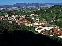
Carmignano is a comune (municipality) of c. 12,000 inhabitants in the province of Prato, part of the Italian region Tuscany. It is located about 20 kilometres (12 mi) west of Florence and about 10 kilometres (6 mi) southwest of Prato. It is the centre of the wine region of the same name.
Contents
- Map of Carmignano Province of Prato Italy
- Geography
- Villages
- Main sights
- Churches
- Villas
- Festivals
- References
Map of Carmignano, Province of Prato, Italy
Geography
Carmignano borders the following municipalities: Capraia e Limite, Lastra a Signa, Montelupo Fiorentino, Poggio a Caiano, Prato, Quarrata, Signa, Vinci.
Villages
Artimino (Carmignano)BaccheretoBarchetto della PinetaCapezzanaCastelvecchio(Carmignano)Colle NovelliComeana (Carmignano)GrumaggioI RenacciIl PinoneLa SerraLazzeraLe BarcheLe FarneteLe GinestreMalinociPianettoPietramarinaSan Martino (Carmignano)Santa Cristina a MezzanaSeanoSpazzavento (Carmignano)Stazione (Carmignano)Verghereto (Carmignano)VerrucolaMain sights
The most important attraction of the town is the church of San Michele e San Francesco (12th century), which houses a "Visitation" by the Renaissance master Pontormo.
The 10th century Rocca (Castle), in the upper part of the town, is well preserved. The frazione of Comeana is home to several Etruscan tombs (such as the Tumulus of Montefortini), while at Artimino is a Medicean villa.