
Basin size 71 sq mi (184 km) Mouth Great South Bay | Length 16 km Mouth elevation 0 | |
 | ||
Main source Cathedral Pines County Park near Middle Island, New YorkApprox. 249 ft (76 m) Discharge Average rate:21 cubic feet per second (1 m/s) | ||
Yaphank willow lake carmans river
The Carmans River is a 10-mile (16 km) long river in Town of Brookhaven in Suffolk County on Long Island.
Contents
- Yaphank willow lake carmans river
- Map of Carmans River Brookhaven NY USA
- List of crossings of the Carmans RiverEdit
- References
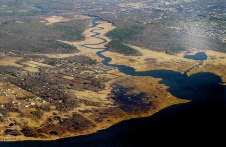
Map of Carmans River, Brookhaven, NY, USA
It is one of the four largest rivers on Long Island and is similar to other Long Island rivers in that is totally groundwater generated (e.g., no lakes), although a lake did exist long ago. Almost all of the river is specifically protected by the Central Long Island Pine Barrens. All of it is designated by New York State as either a "Scenic River" or a "Recreational River."
The river, which was earlier once called the Connecticut River (in connection with early settlers from Connecticut, and also due to the mistaken belief that it is fed underground by that river) is named for Samuel Carman who married into milling families on the river in the 19th century, used it to run a mill, and operated a hunting club for residents from New York City.
It is fresh water for the first eight miles (13 km) and then becomes an estuary for the last two, as it encounters the tidal effects of Great South Bay.
There are four dams on the upper river at Upper Mill Pond, Lower Mill Pond, Southaven County Park, and the Sunrise Highway.
Adjoining the river is the Wertheim National Wildlife Refuge.
The river formed the western boundary of the massive Manor of St. George under William "Tangier" Smith who in the 17th century owned most of modern day Brookhaven south of the Sunrise Highway. A manor subsequently built by the Smith family is located in Shirley at the mouth.
In 1967 Art Cooley, Bellport, New York school teacher, noting a decline in the osprey population on the river was one of the founders of the Environmental Defense Fund which was to lead the fight to ban DDT.
Southaven County Park encompasses upstream parts of the river and special regulations trout fishing can be accessed through them. In recent years, wild turkeys have been re-introduced into this park, and have re-populated many of the surrounding areas.