
Population 15,577 (2011 census) Postcode(s) 4152 Founded 1980 Local time Friday 6:33 PM | Established 1980 Postal code 4152 | |
 | ||
Weather 27°C, Wind E at 16 km/h, 71% Humidity | ||
Carindale is a suburb of Brisbane, Queensland, Australia. It is located 10 kilometres (6.2 mi) east of the CBD, and borders Belmont, Carina, Carina Heights, Mackenzie, Mansfield, Mount Gravatt East, and Tingalpa.
Contents
Map of Carindale QLD 4152, Australia
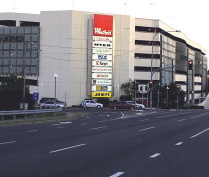
Notable features of the suburb include a large shopping centre - Westfield Carindale, the Pacific Golf Club, Belmont State School, Belmont Bushland Reserve, Belmont Private Hospital (psychiatric only) and Bulimba Creek. The Gateway Motorway borders the suburb. In addition to Indooroopilly in the west; Chermside on the north-side; and Mount Gravatt on the south side, the suburb has been described as a mini-CBD. Public transport runs frequently to and from Carindale and the City via Old Cleveland Road and Creek Road, leading to the South East Busway.
Carindale is represented by Ross Vasta, Steve Minnikin, and Adrian Schrinner at the federal, state, and local levels respectively.
Toponymy
Carindale was the name of a housing estate constructed in the area in 1976, and was taken as the official name of the suburb when it separated from Belmont in 1980. The name itself is a combination of "Carin" from the nearby suburb of Carina, and "dale" meaning valley.
History
The area was first settled by Europeans in the 1850s, with activity focussing on timber and agriculture.
In 1973 Carindale Nursing Home was opened in Foxglove St, Mt Gravatt East and in 1978 permission was granted to the developers to use Carindale as the name of the new shopping centre. In 1980 the suburb of Carindale was created.
Demographics
In the 2011 census, Carindale recorded a population of 15,577 people, 51.6% female and 48.4% male.
The median age of the Carindale population was 40 years of age, 3 years above the Australian median.
67.6% of people living in Carindale were born in Australia, compared to the national average of 69.8%; the next most common countries of birth were New Zealand 3.6%, England 3.5%, South Africa 3%, China 1.6%, India 1.3%.
75.8% of people spoke only English at home; the next most popular languages were 3.6% Greek, 2.4% Cantonese, 2% Mandarin, 1.9% Italian, 1.4% Afrikaans.
Retail
The suburb is home to one of the largest Westfield shopping centres in Brisbane, Westfield Carindale. This large shopping complex has over 400 stores, archored by major tenants:
Housing
The area is of a high socio-economic condition, which is evidenced by the "mini-mansions" that form much of the suburb. In recent years, many high density apartment blocks have been approved throughout the retail area of the suburb and are now under construction. The apartments rise up to the maximum height of 8 floors.