Census division No. 3 Incorporated 1999 (County) Population 4,481 (2016) Province Alberta | Established 1954 Time zone MST (UTC-7) Capital Cardston | |
 | ||
Land use bylaw meeting cardston county
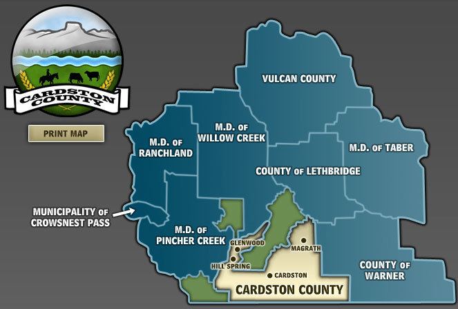
Cardston County is a municipal district in southern Alberta, Canada. It is located in Census Division 3 around the Town of Cardston.
Contents
Map of Cardston County, AB, Canada
The municipal district was established on January 1, 1954, through the amalgamation of the Municipal District of Sugar City No. 5 and part of the Municipal District of Cochrane No. 6. On January 1, 2000, the name was changed from Municipal District of Cardston No. 6 to Cardston County
Demographics
In the 2016 Census of Population conducted by Statistics Canada, Cardston County recorded a population of 4,481 living in 1,043 of its 1,260 total private dwellings, a 7000750000000000000♠7.5% change from its 2011 population of 4,167. With a land area of 3,429.82 km2 (1,324.26 sq mi), it had a population density of 1.3/km2 (3.4/sq mi) in 2016.
In the 2011 Census, Cardston County had a population of 4,167 living in 1,032 of its 1,171 total dwellings, a 3.2% change from its 2006 population of 4,037. With a land area of 3,414.87 km2 (1,318.49 sq mi), it had a population density of 1.2/km2 (3.2/sq mi) in 2011.
The population of Cardston County according to its 2008 municipal census is 4,266.
In 2006, Cardston County had a population of 4037 living in 1,102 dwellings, a 6.7% decrease from 2001. The municipal district has a land area of 3,414.87 km2 (1,318.49 sq mi) and a population density of 1.2/km2 (3.1/sq mi).
In 2001, the county had a population of 4325 in 1118 dwellings, a 5.3% decrease from 1996. On a surface of 3416.24 km² it has a density of 1.3 inhabitants/km². The largest ancestries were English (52.3%), German (33.0%), Scottish (27.3%), Danish (8.7%), Irish (7.4%).
