
Basin area 159 km² | Length 36 km | |
 | ||
Main source Whicher Range72 metres (236 ft) Basin size 159 square kilometres (61 sq mi) Discharge Average rate:10.8 m/s (340,000 ML/a; 380 cu ft/s) | ||
112 haag rd carbunup river western australia 6280
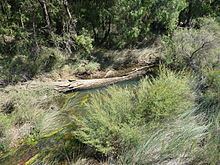
The Carbunup River is located in the south-west corner of Western Australia. The mouth of the Carbunup River is approximately 20 kilometres (12 mi) west of Busselton where the river flows into Geographe Bay.
Contents
The Carbunup River is 36 kilometres (22 mi) in length and flows north from its headwaters in the Treeton State Forest/Whicher Range in the Shire of Augusta-Margaret River.
The nearest water courses are Mary Brook to the West and Buayanyup River to the east; both of these rivers travel in a parallel direction to the Carbunup River. The catchment area is 170 square kilometres (65.6 sq mi) of which 55% is cleared. The Carbunup River is located in the Leeuwin-Naturaliste area where it crosses two physiographic regions, the 15 km wide Swan Coastal Plain and the gently undulating Blackwood Plateau.
The only tributary of the river is Island Brook.
12 vickery street carbunup river
History
The river was originally named the Lennox River after Lennox Bussell by Captain John Molloy in 1835. The name was changed to Carbunup River, the aboriginal word that means either 'place of a kindly stream', 'place of cormorants' or 'place of the stinkwood thicket'.