
District 1st District Time zone PST (UTC+8) Area 82.97 km² | Barangays ZIP code 2911 Local time Friday 6:21 AM Dialling code 77 | |
 | ||
Weather 20°C, Wind NW at 0 km/h, 77% Humidity | ||
Sabo dam carasi ilocos norte july 2014
Carasi is a fifth class municipality in the province of Ilocos Norte, Philippines. According to the 2015 census, it has a population of 1,567 people, making it the least populous municipality in the province.
Contents
- Sabo dam carasi ilocos norte july 2014
- Map of Carasi Ilocos Norte Philippines
- Geography
- Barangays
- Demographics
- Local government
- Government seal
- References
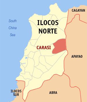
Map of Carasi, Ilocos Norte, Philippines
Geography
Carasi is a land-locked town situated in the eastern border of Ilocos Norte. It has an area of 157.48 km2. Vintar is situated in the north of Carasi, Calanasan in the east, Nueva Era in the south and Piddig in the west. It is in the foot of the Cordillera Mountains.
Barangays
Carasi is politically subdivided into 3 barangays.
Demographics
In the 2015 census, the population of Carasi was 1,567 people, with a density of 19 inhabitants per square kilometre or 49 inhabitants per square mile.
Local government
As of the term 2013-2016, these are the elected officials of Carasi:
Government seal
Shield, denotes that Carasi is within the Province of Ilocos Norte
Deer, represents hunting as means of livelihood of the townspeople
Pine Tree, stands for the forest products that abound in the town
Center Design, signifies defense and protection (shield); hardwork (bolo); and patriotism and bravery (spear).