
Country United States GNIS feature ID 0358717 Area 31.5 km² Population 3,429 (2010) | State Hawaii FIPS code 15-03850 Elevation 381 m Zip code 96704 Area code Area code 808 | |
 | ||
Time zone Hawaii-Aleutian (UTC-10) | ||
Captain Cook is a census-designated place (CDP) in Hawaiʻi County, Hawaiʻi, in the United States located in the District of South Kona. The community, which is actually located in the land division of Kealakekua, is so named because the post office for the area was located in the Captain Cook Coffee Co. during the early 1900s. As of the 2000 census, the CDP population was 3,206. The population increased by 7.0% to 3,429 at the 2010 census.
Contents
- Map of Captain Cook HI USA
- Geography
- Demographics
- Lava zones redlining and insurance issues
- Points of interest
- Education
- References
Map of Captain Cook, HI, USA
Geography
Captain Cook is located at 19°29′54″N 155°54′15″W (19.498211, -155.904275). According to the United States Census Bureau, the CDP has a total area of 12.2 square miles (32 km2), all of it land.
Most of Captain Cook lies between the 800-foot (240 m) and 2,000-foot (610 m) elevation, which makes it ideal as a coffee growing region. It sits on the top of an ancient fault which created the famous Kealakekua Bay. Prior to the 1960s, most of Captain Cook was part of the vast Kealakekua Ranch, founded in the 1850s by English immigrant Henry Nicholas Greenwell.
Demographics
As of the census of 2010, there were 3,429 people in 1,258 households residing in the CDP. The population density was 281.1 people per square mile (108.9/km²). There were 1,386 housing units at an average density of 113.6 per square mile (44.0/km²). The racial makeup of the CDP was 31.44% White, 0.67% African American, 0.38% American Indian & Alaska Native, 27.65% Asian, 10.67% Native Hawaiian & Pacific Islander, 2.16% from other races, and 27.03% from two or more races. Hispanic or Latino of any race were 9.51% of the population.
There were 1,258 households out of which 22.0% had children under the age of 18 living with them. The average household size was 2.73.
In the Captain Cook CDP the population was spread out with 20.6% under the age of 18, 7.0% from 18 to 24, 11.6% from 25 to 34, 15.4% from 35 to 49, 28.3% from 50 to 64, and 17.1% who were 65 years of age or older. For every 100 females there were 101.1 males. For every 100 males there were 98.9 females.
The median income for a household in the CDP at the 2000 census was $47,644, and the median income for a family in 2000 was $60,179. Males had a median income of $36,250 in 2000 versus $27,155 for females. The per capita income for the CDP in 2000 was $21,237. About 5.4% of families and 8.5% of the population were below the poverty line in 2000, including 10.5% of those under age 18 and 3.6% of those age 65 or over.
Lava zones, redlining, and insurance issues
Captain Cook shares much in common with the District of Puna. Both districts are situated on active volcanoes and contain large sections of land that are in Lava Flow Hazard Zone 2. Additionally, new lava hazard zones 11, 12, and 13 are being established to account for current flow activity to reduce redlining.
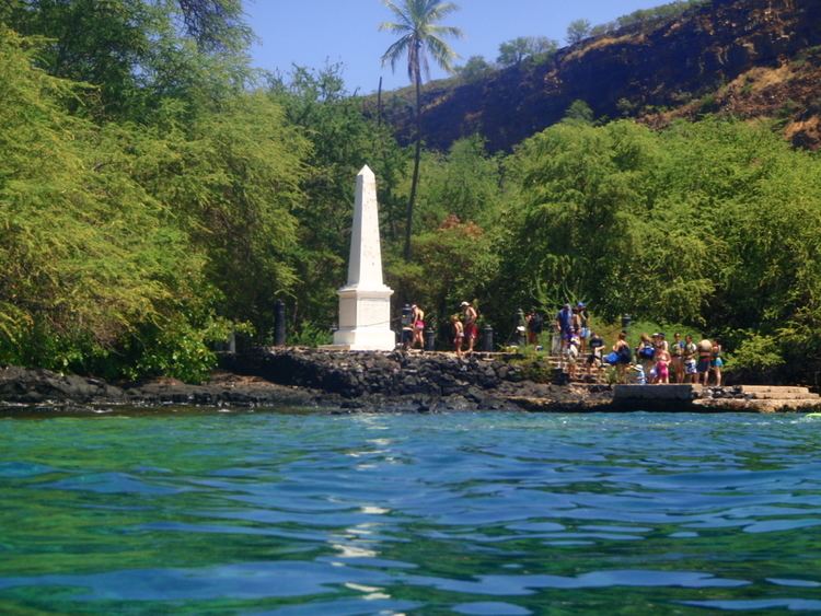
Points of interest
Education
Hawaii Department of Education operates public schools. Konawaena Elementary School is in Captain Cook CDP.