
Time zone CET/CEST (UTC+1/+2) Area 76.2 km² Population 6,641 (31 Dec 2008) Dialling code 04478 | Elevation 46 m (151 ft) Postal codes 49692 Local time Wednesday 11:43 PM Postal code 49692 | |
 | ||
Weather 7°C, Wind W at 19 km/h, 93% Humidity | ||
Cappeln is a municipality in the district of Cloppenburg, in Lower Saxony, Germany. It is situated approximately 7 km southeast of Cloppenburg.
Contents
Map of 49692 Cappeln, Germany
Cappeln consists of the following rural communities:
History
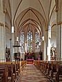
In 1159 Cappeln became independent from nearby Emstek and founded its own parish. The name derives from the word "chapel". The old church (built in 1150) was only demolished in 1900 to make room for the current St. Peter and Paul church.
From 1914 to 1965 a local railway linked Cappeln to Cloppenburg and Vechta, first the only station was in Schwichtler.
Architecture
References
Cappeln Wikipedia(Text) CC BY-SA