
State Maryland Time zone Eastern (EST) (UTC-5) Area code(s) 301 and 240 Elevation 37 m Population 4,476 (2013) | County Prince George's ZIP codes 20700-20799 Area 207 ha Local time Wednesday 4:46 PM | |
 | ||
Weather 19°C, Wind SW at 26 km/h, 15% Humidity University Maple Springs Baptist Bible College and Seminary | ||
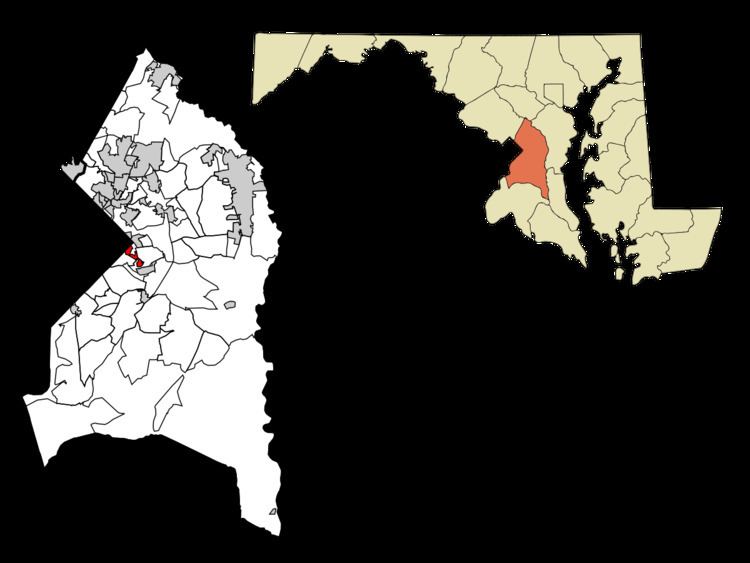
Capitol Heights is a town in Prince George's County, Maryland, United States. The population was 4,337 at the 2010 census. Development around the Capitol Heights Metro station has medical facilities and eateries to support the community. The Washington Redskins football stadium is just to the east of Capitol Heights, near the Capital Beltway (I-95/495) and Kingdom Square (formerly Hampton Mall) shopping center which features a hotel and eateries.
Contents
- Map of Capitol Heights MD 20743 USA
- Bordering areas
- Geography
- Previous mayors
- Town council
- 2010 census
- 2000 census
- Government
- Law enforcement
- History
- Community organizations
- Education
- Notable people
- References
Map of Capitol Heights, MD 20743, USA
The town borders Washington, D.C., and has a ZIP code of 20743.
Bordering areas
Geography
Capitol Heights is located at 38°52′55″N 76°54′52″W (38.881862, -76.914474).
According to the United States Census Bureau, the town has a total area of 0.80 square miles (2.07 km2), all of it land.
Previous mayors
Town council
2010 census
As of the census of 2010, there were 4,337 people, 1,482 households, and 1,040 families residing in the town. The population density was 5,421.3 inhabitants per square mile (2,093.2/km2). There were 1,622 housing units at an average density of 2,027.5 per square mile (782.8/km2). The racial makeup of the town was 3.3% White, 91.3% African American, 0.3% Native American, 0.1% Asian, 3.1% from other races, and 1.9% from two or more races. Hispanic or Latino of any race were 5.4% of the population.
There were 1,482 households of which 42.0% had children under the age of 18 living with them, 34.0% were married couples living together, 28.4% had a female householder with no husband present, 7.8% had a male householder with no wife present, and 29.8% were non-families. 25.1% of all households were made up of individuals and 7.3% had someone living alone who was 65 years of age or older. The average household size was 2.92 and the average family size was 3.48.
The median age in the town was 34.9 years. 27.3% of residents were under the age of 18; 10.3% were between the ages of 18 and 24; 27.3% were from 25 to 44; 26.1% were from 45 to 64; and 9.1% were 65 years of age or older. The gender makeup of the town was 46.0% male and 54.0% female.
2000 census
As of the census of 2000, there were 4,138 people, 1,441 households, and 1,014 families residing in the town. The population density was 5,047.3 people per square mile (1,948.4/km²). There were 1,603 housing units at an average density of 1,955.2 per square mile (754.8/km²). The racial makeup of the town was 92.85% Black or African American, 4.81% White, 0.27% Native American, 0.36% Asian, 0.36% from other races, and 1.35% from two or more races. Hispanic or Latino of any race were 0.87% of the population.
There were 1,441 households out of which 37.5% had children under the age of 18 living with them, 35.2% were married couples living together, 28.5% had a female householder with no husband present, and 29.6% were non-families. 25.7% of all households were made up of individuals and 8.0% had someone living alone who was 65 years of age or older. The average household size was 2.87 and the average family size was 3.41.
In the town, the population was spread out with 30.8% under the age of 18, 6.9% from 18 to 24, 32.6% from 25 to 44, 21.4% from 45 to 64, and 8.3% who were 65 years of age or older. The median age was 34 years. For every 100 females there were 84.8 males. For every 100 females age 18 and over, there were 78.8 males.
The median income for a household in the town was $46,667, and the median income for a family was $53,826. Males had a median income of $36,950 versus $35,225 for females. The per capita income for the town was $18,932. About 9.3% of families and 11.4% of the population were below the poverty line, including 15.8% of those under age 18 and 9.6% of those age 65 or over.
Government
The Town of Capitol Heights operates under the council-manager form of government. The Town Administrator serves as chief administrative officer and directly reports to the Town Council. The Town has approximately 20.0 FTE (full-time equivalents) who serve in the following areas:
Administration and Finance Neighborhood Services (Code Enforcement) Police Economic Development
Michelle Bailey-Hedgepeth has served as the Town Administrator since September 2011.
Law enforcement
Capitol Heights is served by its own police department. Chief Anthony L. Ayers was selected in November 2012 to serve as the Chief of Police.
History
In 1904, Washington, D.C., was growing by leaps and bounds. The overcrowding and the improved public transportation made the idea of living on the outskirts increasingly appealing to people looking for housing. Recognizing the opportunity, Baltimore resident Otway B. Zantzinger acquired 400 hilly acres just beyond the eastern corner of the District of Columbia. He divided the tract into 4,000 lots and began to sell them at prices ranging from $20 to $150 each. He advertised a picturesque view of Washington, D.C., a proposed electric railway, drinking water from crystal-clear springs, nothing down and a dollar a month, no interest, no landlords, and, in the custom and vernacular of the times, "no colored people." Many buyers bought two lots in this haven that was to become Capitol Heights.
While awaiting their "proposed electric railway," commuters to the city could walk about a mile (often through mud) to the District Line station at what is now Seat Pleasant and board a rail car into Washington, DC.
The absence of paved roads, sidewalks, street lights, and other public services, including the electric railway, began to cast a pall over Zantzinger’s vision of bliss. In 1910, the approximately 200 householders voted to incorporate their community as Capitol Heights. Over the next 50 years, the town made strides in improving its infrastructure and services. It established its own fire department and public works department and built facilities to house them and other elements of the government. By the 1970s, when its population had reached about 3,800, the town’s central business district had started to decline.
A rebuilt Central Avenue had diverted lucrative traffic around the town, and parking facilities were inadequate for what traffic there was. Rising instances of crime and modest incomes of the residents were cited as other reasons for the town’s ailing economy. The town established its own police department and pinned its hopes on the planning reports of the Washington Metropolitan Area Transit Authority.
In 1980, that long-promised "electric railway" finally arrived. Capitol Heights got its own station on the Washington Metro Blue Line, providing easy access to the entire metropolitan region and national transportation facilities. The land around the station has been declared an Enterprise Zone, which the town is promoting as one of its paths to restoring prosperity. Today, over 95% of the population of Capitol Heights is African-American, and the town has had four African-American mayors.
Community organizations
The Capitol Heights/Seat Pleasant chapter of the Prince George's County Boys and Girls Club, supports the youth with after-school programs and athletic programs, along with mentoring boys and girls.
The Capitol Heights conflict-mediation program focuses on resolving differences between youths in the area.
Education
Capitol Heights is a part of the Prince George's County Public Schools system.
Capitol Heights is zoned to: Elementary Schools Website
Middle Schools
High Schools
Academies(Elementary and Middle)