
 | ||
The Cape to Cairo Road or Pan-African Highway, sometimes called the Great North Road in sub-Saharan Africa, was a proposed road that would stretch the length of Africa, from Cape Town to Cairo, through the Cape to Cairo Red Line of British colonies. The proposal was similar to the Cape to Cairo Railway, another proposed infrastructure project through the same colonies. Neither were completed before British colonial rule ended in the colonies.
Contents
In the 1980s the plan was revived with modifications as the Cairo–Cape Town Highway, known as Trans-African Highway 4, in the transcontinental road network being developed by the United Nations Economic Commission for Africa (UNECA), the African Development Bank (ADB), and the African Union, as part of the Trans-African Highway network.
History
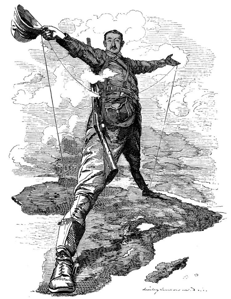
From about 1890, some in the British Empire envisioned a road that would stretch across the continent from south to north, running through the British colonies of the time, such as the Union of South Africa, Southern and Northern Rhodesia and Nyasaland, Kenya, Sudan and Egypt. The road would create cohesion between the British colonies of Africa, it was thought, and give Britain the most important and dominant political and economic influence over the continent, securing its position as a global colonial power. The road would also link some of the most important cities on the continent, including Cape Town, Johannesburg, Pretoria, Harare (then Salisbury), Lusaka, Nairobi, Khartoum and Cairo. One of the main proponents of the route was Cecil John Rhodes, though his preference was for a railway. German East Africa (Tanganyika, now Tanzania) was a gap in the British territories, but Rhodes in particular felt that Germany ought to be a natural ally. Shortly before his death he had persuaded the German Kaiser to allow access through his colony for the Cape to Cairo telegraph line (which was built as far north as Ujiji but never completed). In 1918 Tanganyika became British and the gap in territories was filled.
One of the biggest problems was the decline of the Empire and fragmentation of the British colonies. Even though Egypt became independent in 1922, British influence there was strong enough for Cairo to be viewed as part of the British sphere of interest, and the idea of a road continued. After Egypt, Sudan was the next to become independent in 1956, putting an end to the colonial motivation of the dream.
France had a rival strategy in the late 1890s to link its colonies from west to east across the continent, Senegal to Djibouti. Southern Sudan and Ethiopia were in the way, but France sent expeditions in 1897 to establish a protectorate in southern Sudan and to find a route across Ethiopia. The scheme foundered when a British flotilla on the Nile confronted the French expedition at the point of intersection between the French and British routes, leading to the Fashoda Incident and eventual diplomatic defeat for France.
The first known attempt to drive a vehicle from Cape Town to Cairo was by a Captain Kelsey in 1913-14 but this came to an untimely end when he was killed by a leopard in Rhodesia. The first successful journey was Court Treatt expedition of 1924 led by Major Chaplin Court Treatt which drove two Crossley light trucks leaving Cape Town on 23 September 1924 and arriving in Cairo on 24 January 1926.
The original route today
The road remains a somewhat elusive idea. There are numerous routes. Some sections, especially in Kenya, Ethiopia, South Sudan and Sudan, are unpassable at times due to political and security concerns. BDlive reported in May 2016 that the entire route had recently been paved, reporting that Hell's Road was "the final untarred section that would otherwise realise Cecil John Rhodes’s dream of a smooth connection between the Cape and Cairo....Hell's Road was recently tarred. A number of adventure travel companies offer Cape to Cairo overland expeditions using four-wheel drive trucks with bus bodies.
Starting from the south, the first section of the road that runs through South Africa is called the N1, linking Cape Town in the south with Beit Bridge on the Limpopo River between South Africa and Zimbabwe. There are numerous alternative routes in South Africa and two possible routes through Zimbabwe, via Bulawayo or Harare.
From Lusaka, Zambia's Great North Road continues the route into Tanzania. The surface may be badly potholed in some sections through Zambia and points north.
In Tanzania there are a number of roads could be deemed to be part of the route, the clear definitions and markings that are characteristic of the Pan-American Highway do not apply here. Most would consider it to be the road from Tunduma on the Tanzania-Zambia border, through Morogoro to the Arusha turnoff, and north to Arusha, then to Nairobi in Kenya. There was a marker in the 1930s in Arusha, Tanzania, to indicate the midpoint of the road.
Kenya has a tarred highway to its border with Sudan but the roads in southern Sudan are very poor and made frequently impassable, so that even without the conflicts that have afflicted Sudan, the route through Ethiopia is generally preferred by overland travellers. The route from Isiolo in Kenya to Moyale on the Ethiopian border through the northern Kenyan desert has sometimes been dangerous due to bandits.
Through Ethiopia the route is mainly tarred but some sections may have deteriorated severely. A track from Lake Tana to Gedaref takes the route into Sudan.
The most difficult section in the whole Cape to Cairo journey is across the Nubian Desert in northern Sudan between Atbara and Wadi Halfa, but there is also a railway traversing this route which can take vehicles in piggyback fashion. Tarred highways continue the route to Cairo. An Egyptian and a Sudanese company committed in January 2010 to build a 400 kilometres (250 mi) stretch of highway between Aswan and Dongola in Sudan. The stretch of highway between Dongola and Wadi Halfa is complete as of June 2010 and a land port opened between Sudan and Egypt in 2015. At Wadi Halfa on Lake Nasser there is land port between Sudan and Egypt.
Cairo–Cape Town Highway
The Cairo–Cape Town Highway follows much of the Cape-to-Cairo Road's route but it passes through Ethiopia and not through Johannesburg and Harare (formerly Salisbury). This new route has a length of 10,228 km. As South Sudan has a paved link to its border with Kenya, ultimately a route through southern Sudan via Khartoum and South Sudan may provide a shorter alternative to the Ethiopian route.
The modern revival of the plan occurred in the 1980s. South Africa was not originally included in the route which was first planned in the Apartheid era, but it is now recognized that it would continue into that country. The consultants' report suggested Pretoria as end, which seems somewhat arbitrary and as a major port, Cape Town is regarded as the southern end of regional highways in Southern African Development Community countries. The highway may be referred to in documents as the Cairo–Gaborone Highway or Cairo – Pretoria Highway.
Modern route today
The stretch of highway between Dongola and Wadi Halfa in Northern Sudan and the Egypt-Sudan border are now accessible by road through the Qastal-Ashkeet border post.
The Ethiopian section is all tarmac road, although much of the Ethiopian section passes through mountainous terrain and parts of the road may be hazardous as a result.
In northern Kenya the section has been hazardous due to the activities of armed bandits. The road has been dubbed "Hell's Road" by overland travellers.
The gravel section through Babati and Dodoma in central Tanzania is partially tarred, and passable throughout most of the year, and the alternative paved eastern route to Iringa via Moshi, Korogwe, Chalinze and Morogoro may also be considered to have a better claim to be part of the highway.
Between Chalinze and Kapiri Mposhi in Zambia via Iringa, the highway uses an important regional route, the Tanzam Highway, also called the Great North Road in Zambia. This highway has the distinction of being the only link between any of Africa's five major regions which is paved, linking East Africa to Southern Africa. It is the most used of any such inter-regional road on the continent.