
 | ||
Offshore water bodies Southern Indian OceanBass Strait | ||
Cape grim grass fed beef
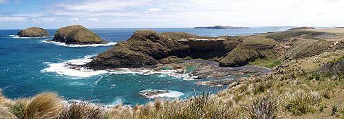
Cape Grim is the northwestern point of Tasmania, Australia.
Contents
Map of Cape Grim, Tasmania, Australia
It is the location of the Cape Grim Baseline Air Pollution Station which is operated by the Australian Bureau of Meteorology in a joint programme with the CSIRO. The Station was established in 1976 and has been operating ever since.
Geography
What makes Cape Grim unique is its isolated geographic location. The next land mass directly west of Cape Grim is not Africa, but the southern tip of Argentina. Winds that make their way to Cape Grim from Antarctica and the Indian Ocean hit no significant land mass. Air pollution values collected at Cape Grim represent the closest representation attainable of a global average.
History
This headland was first charted and named Cape Grim by Matthew Flinders on 7 December 1798, as he sailed from the East in the Norfolk and found a long swell coming from the South-west, confirming for the first time that Van Diemen's Land was separated from the Australian mainland by a strait which he named Bass Strait.
In 1828 Victory Hill at Cape Grim was the site of the Cape Grim massacre of thirty aboriginal Tasmanians from the Pennemukeer band of the North West tribe by four shepherds in response to sheep being driven over the cliff six weeks earlier by the Peerapper band.