
Type Air Force Station Year built 1950 | In use 1950-1981 Controlled by United States Air Force | |
 | ||
Code ADC ID: P-56, NORAD ID: Z-56 Garrison 771st Aircraft Control and Warning Squadron Similar Hutchinson Air Force Station, Kirksville Air Force Station, Cottonwood Air Force Station, Las Cruces Air Force Station | ||
Cape Charles Air Force Station is a closed United States Air Force General Surveillance Radar station. It is located 3.6 miles (5.8 km) south of Townsend, Virginia. It was closed in 1981.
Contents
History
The military history of this station begins in 1941 when the United States Army established Fort Winslow at this location as a coastal defense artillery installation to complement Fort Story in Virginia Beach in order to protect Chesapeake Bay. In 1942 it was renamed Fort John Custis. Army artillery included two 16" guns, four 8" guns and four 155mm pieces. After the end of World War II the army inactivated the fort.
The United States Air Force acquired the Fort Custis site from the army in 1948 as a temporary Lashup radar site, being designated L-15. It installed AN/CPS-5 and AN/CPS-4 radars when the air force authorized the Air Defense Command to put thirteen radar stations in operation in the Northeastern United States. This temporary system was named Lashup to distinguish it from the interim system for which the air force was seeking appropriations. The 771st Aircraft Control and Warning Squadron was activated to operate the site. A small airfield was established near the station, to provide logistical support due to its isolated location at the southern end of the Delmarva Peninsula.
L-15 was designated as Cape Charles Air Force Station, and it was one of twenty-eight stations built as part of the second segment of the permanent radar network. Prompted by the start of the Korean War, on July 11, 1950, the Secretary of the Air Force asked the Secretary of Defense for approval to expedite construction of the permanent network. Receiving the Defense Secretary’s approval on July 21, the air force directed the Corps of Engineers to proceed with construction. Because of difficulties with the new radar equipment, Cape Charles AFS initially received its radar equipment from the former Fort Curtis Lashup site to expedite operational status. Thus it was redesignated as LP-56. The 771st AC&W Squadron, continued operating the AN/CPS-4 and as of April 1952 an AN/FPS-3 radar as well. The AN/FPS-3 remained operational until 1962. Initially the station functioned as a ground-control intercept (GCI) and warning station. As a GCI station, the squadron's role was to guide interceptor aircraft toward intruders picked up on the unit's radar.
In 1955 an AN/FPS-8 was installed, converted to an AN/GPS-3, and operated through 1958. By the end of that year, two AN/FPS-6 heightfinder radars were activated. During 1959 Cape Charles AFB joined the Semi Automatic Ground Environment (SAGE) system, initially feeding data to DC-04 at Fort Lee AFS, Virginia. After joining, the squadron was re-designated as the 771st Radar Squadron (SAGE) on 1 October 1959. The radar squadron provided information 24/7 the SAGE Direction Center where it was analyzed to determine range, direction altitude speed and whether or not aircraft were friendly or hostile. On 31 July 1963, the site was redesignated as NORAD ID Z-56.
In addition to the main facility, Cape Charles AFS operated several unmanned AN/FPS-14 Gap Filler sites:
In 1963 the site hosted AN/FPS-7, AN/FPS-6, and AN/FPS-26A radars. In 1963 the site also became an ADC/FAA joint-use facility. The facility came under TAC jurisdiction in 1979 with the inactivation of Aerospace Defense Command and the activation of ADTAC. Air Force use ended in 1981 and Cape Charles AFS was replaced by the Naval Air Station Oceana, Virginia, Joint Surveillance System (JSS) radar site.
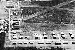
Today, the former Cape Charles Air Force Station has been obliterated, and is now part of Eastern Shore of Virginia National Wildlife Refuge, although a few minor service buildings remain. The housing area remains and the units are now in private hands. The Gap Filler support buildings at Z-56A and Z-56C remain, although the tower and radar are gone. Z-56B is now part of a golf course.