
Construction concrete tower Intensity 1,200 candela Opened 1950 Year first constructed 1950 | Light source solar power Height 9.1 m Focal height 55 m | |
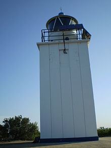 | ||
Location KurnellNew South WalesAustralia Tower shape square prism tower with balcony and lantern Markings / pattern white tower and lantern Similar Kamay Botany Bay National, Point Stephens Light, Western Channel Pile Light, Eastern Channel Pile Light, Burrewarra Point Light | ||
Cape Baily Light is an active lighthouse located at Cape Baily, a headland at the south side of the entrance to Botany Bay, New South Wales, Australia. The light serves in help north-bound shipping hug the coast to avoid the strong southerly currents further out to sea.
Contents
Map of Cape Baily Lighthouse, Kurnell NSW 2231, Australia
History
The light was first considered in 1931 but only constructed in 1950. Its lantern enclosure was taken from an unknown late-19th-century lighthouse. It is currently solar powered.
Site operation
The light is operated by the Australian Maritime Safety Authority, while the site is managed by Department of Environment, Climate Change and Water as part of the Botany Bay National Park.
Visiting
The site is open, and accessible by a hike of about 2.5 hours round trip from the end of Solander Road in Kurnell, but the tower is closed.