
Province Province of Alicante | ||
 | ||
Similar Costa Blanca, Playa de la Granadella, Montgó Massif, Cape San Antonio - Spain, Natural Park of Penyal d'I | ||
Cap de la nau x bia 17 11 2015
The Cap de la Nau ([ˈkab de la ˈnaw]) or Cabo de la Nao ([ˈkaβo ðe la ˈnao]), literally Cape of the Ship, is a headland located central-eastern coastal Spain on the Gulf of Valencia, Mediterranean Sea. In English, it is also known as Cape Nao.
Contents
Map of Cabo de la Nao, Alicante, Spain
Geography
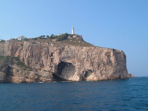
Cap de la Nau is in the municipality of Xàbia, within the Mediterranean province of Alicante, in the comarca of Marina Alta, and is the easternmost point of the Valencian Community. It marks the southern limit of the Gulf of Valencia, and points towards the nearby island of Formentera in the Balearic Islands.
The cape is rocky, steep and mostly composed of limestone. Beneath the headland there is a large cave, known as Cova dels Orgues (or Cueva de los Órganos in Spanish) that can only be approached from the sea.
Atop the headland, at an elevation of 120 metres (390 ft), stands the Cap de la Nau lighthouse, providing an important aid to navigation.