
Country United States FIPS code 37-10240 Elevation 797 m Zip code 28716 Local time Wednesday 8:58 AM | State North Carolina Time zone Eastern (EST) (UTC-5) GNIS feature ID 1019518 Area 9.8 km² Population 4,144 (2013) Area code 828 | |
 | ||
Weather 7°C, Wind NW at 11 km/h, 52% Humidity | ||
Canton is the second largest town in Haywood County, North Carolina, United States. It is located about 13 miles (21 km) west of Asheville, North Carolina and is part of the Asheville Metropolitan Statistical Area. The town is named after the city of Canton, Ohio. The population was 4,227 people at the 2010 Census.
Contents
Map of Canton, NC 28716, USA
History
The area was first settled in the late 1780s. By 1790 Jonathan McPeters was farming the banks of the Pigeon River where Canton now stands. Around 1815 the first church was built in what was to become Canton; it was called the Locust Old Field Baptist Church.
Canton was founded in 1889 as Buford, later that same year the name was changed to Vinson. The name was changed to Pigeon Ford in 1891. The name was changed to Canton in 1893. The town was named for Canton, Ohio, the source of the steel for the bridge over the Pigeon River.
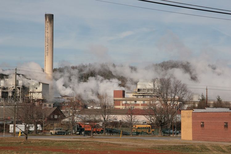
Canton was the site of a Champion International Paper factory. Champion contributed largely to the local economy, and was the largest employer in Canton. Upon Champion's decision to close the plant in 1997, the employees of Champion purchased the plant and formed Blue Ridge Paper Company. Under an ESOP, the employees owned a 45% stake in the new company, although it has since been sold. The plant is now owned by Evergreen Packaging.
The Canton Main Street Historic District and Colonial Theater are listed on the National Register of Historic Places.
Demographics
As of the census of 2000, there were 4,029 people, 1,819 households, and 1,118 families residing in the town. The population density was 1,054.6 people per square mile (407.2/km²). There were 2,003 housing units at an average density of 524.3 per square mile (202.5/km²). The racial makeup of the town was 96.13% White, 1.59% African American, 0.57% Native American, 0.10% Asian, 0.94% from other races, and 0.67% from two or more races. Hispanic or Latino of any race were 2.41% of the population.
There were 1,819 households out of which 22.7% had children under the age of 18 living with them, 47.7% were married couples living together, 10.5% had a female householder with no husband present, and 38.5% were non-families. 35.4% of all households were made up of individuals and 20.3% had someone living alone who was 65 years of age or older. The average household size was 2.17 and the average family size was 2.78.
In the town, the population was spread out with 19.6% under the age of 18, 6.9% from 18 to 24, 26.0% from 25 to 44, 24.1% from 45 to 64, and 23.5% who were 65 years of age or older. The median age was 43 years. For every 100 females there were 85.9 males. For every 100 females age 18 and over, there were 81.7 males.
The median income for a household in the town was $28,775, and the median income for a family was $38,191. Males had a median income of $28,792 versus $22,143 for females. The per capita income for the town was $17,995. About 9.5% of families and 13.3% of the population were below the poverty line, including 24.6% of those under age 18 and 5.9% of those age 65 or over.