
 | ||
Hotel canal de castilla en villamuriel del cerrato palencia
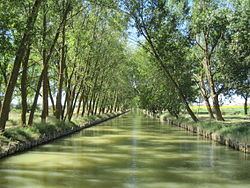
The Canal of Castile (Canal de Castilla in Spanish) is a canal in the north of Spain. Constructed between the last half of the 18th century and the first half of the 19th century, it runs 207 km through the provinces of Burgos, Palencia and Valladolid, in the Autonomous Community of Castile and León. Width ranges between 11 m (36 ft) and 22 metres, depth between 1.8 m (5 ft 11 in) and 3 metres.
Contents
- Hotel canal de castilla en villamuriel del cerrato palencia
- Map of Canal de Castilla Spain
- History
- Ecology
- Municipalities crossed over by Canal
- References
Map of Canal de Castilla, Spain
It is protected by a heritage listing, having been declared Bien de interés cultural in 1991. Parts of it are still in use, irrigating 48 municipalities.
History
The canal was planned by the Marques de la Ensenada during Fernando VI's reign. Its purpose was to boost trade by allowing Tierra de Campos' wheat grain production to be transported from Castile to the northern harbour of Santander and to other markets from there; vice versa, the canal was also meant to facilitate the inflow of products from the Spanish colonies into Castile.
The Spanish War of Independence, budgetary constraints and the difficult passage of the Cantabrian Mountains hampered and eventually reduced the initial plan of a 400 km so the canal never reached the Bay of Biscay as initially planned. Overall, its construction took almost 100 years (from 1753 to 1849) and was eventually halted when railroads were built in northern Spain in the nineteenth century, superseding the project.
The canal was most used during the 1850-1870 period, when up to 400 barges plied the canal towed by beasts of burden. Later on, the canal evolved into the spine of a huge irrigation system due to its relative inefficiency vs. railfreight as a means of transport. The locks on the canal were decommissioned in the twentieth century.
Similar to an inverted 'Y' in layout, the canal stretches 207 km (129 mi), linking the towns of Alar del Rey (Palencia), considered the beginning of the Northern Branch, Valladolid and Medina de Rioseco, lying at the end of the Southern Branch and Campos Branch respectively.
Ecology
The countryside crossed by the canal is of interest for its birdlife. In the Tierra de Campos there are two large Special Protection Areas (La Nava-Campos Norte and La Nava-Campos Sur) which are notable for the birds such as great bustards (Otis tarda) which live in the dryland farming areas (sometimes described as "steppes") which are typical of the region. The canal, on the other hand, provides habitats for wetland birds such as the bittern (Botaurus stellaris).
The canal lends its name to two Sites of Community Importance alongside the watercourse:
In 2006-10 the European Union's Life Programme funded restoration of wetlands in the province of Palencia with the aim of improving the canal's contribution to biodiversity. Birds of interest to the project include:
The improvements included facilities for bird-watching: two observatories were positioned close to two of the wetlands with the greatest ornithological interest along the Canal of Castile: the Venta de Valdemudo (Becerril de Campos) and the Valdemorco (Boadilla del Camino) lagoons. These observatories complemented one already existing (in Toja de las Ribas, Ribas de Campos) before the LIFE project.
Municipalities crossed over by Canal
Ordered North to South, East to West.