
Country Mexico Area 57,507 km2 | Capital San Francisco de Campeche Governor Fernando Ortega Population 822,441 (2010) | |
Colleges and Universities Autonomous University of Campeche, Universidad Autónoma del Carmen Destinations Campeche, Ciudad del Carmen, Champotón - Campeche, Calkiní, Calakmul | ||
Campeche ( ), officially Free and Sovereign State of Campeche (Spanish: ), is one of the 31 states which, with the Federal District, comprise the 32 Federal Entities of Mexico. Located in Southeast Mexico, it is bordered by the states of Yucatán to the north east, Quintana Roo to the east, and Tabasco to the south west. To the south it is bordered by the Petén department of Guatemala, to the east by Belize and to the west by the Gulf of Mexico. The state capital, also called Campeche, was declared a World Heritage Site in 1997. The formation of the state began with the city, which was founded in 1540 as the Spanish began the conquest of the Yucatán Peninsula. During the colonial period, the city was a rich and important port, but declined after Mexico’s Independence. Campeche was part of the province of Yucatán but split off in the mid-19th century, mostly due to political friction with city of Mérida. Today, much of the state’s economic comeback is due to the finding of petroleum offshore in the 1970s, which has made the coastal cities of Campeche and Ciudad del Carmen important economic centers. The state has important Mayan and colonial sites but they are not as well known or visited as others in the Yucatán.
Contents
- Map of Campeche
- Campeche mexico best kept beachfront secret
- Campeche juvenile tarpon
- Geography and environment
- History
- Culture
- Travel diary march 7 2011 we visit campeche and calakmul seafood restaurant
- References
Map of Campeche
Campeche mexico best kept beachfront secret
Campeche juvenile tarpon
Geography and environment
The state of Campeche is located in southeast Mexico, on the west side of the Yucatan Peninsula. The territory is 56,858.84km2, which is 2.6% of Mexico’s total. It borders the states of Yucatán, Quintana Roo and Tabasco, with the country of Belize to the east, Guatemala to the south and the Gulf of Mexico to the west. Politically, it is divided into eleven municipalities: Calkiní, Calakmul, Campeche, Candelaria, Champotón, Ciudad del Carmen, Escárcega, Hecelchakán, Hopelchén, Palizada and Tenabo.
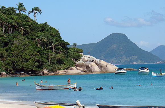
Campeche is a relatively flat area of Mexico with 523 km of shoreline on the Gulf of Mexico. Most of the surface is of sedimentary rock much of which is from marine origin. The area with the highest elevations is near the borders with Guatemala and Quintana Roo. Notable elevations include Cerro Champerico (390 meters), Cerro los Chinos (370 meters), Cerro El Ramonal (340 meters), Cerro El Doce (250 meters) and Cerro El Gavilán (210 meters). However, these hills are separated by large expanses of lower flat land.(mediofisico) In the south of the municipality of Champotón begin a series of rolling hills known as the Sierra Alta or Puuc, which extend northeast to Bolonchen and then into the state of Yucatán. These have only an average altitude of between forty and sixty meters with some reaching 100 meters. There other areas of these rolling hills, near the city of Campeche with main ones known as Maxtum, Boxol and El Morro. Another set is called the Sierra Seybaplaya in the center of the state.
Rainforest areas subdivide into a number of types which include perennial tall tree rainforest, semi perennial tall tree rainforest, deciduous medium height tree rainforest, semi deciduous medium height tree rainforest, deciduous low height tree rainforest and semi perennial low height tree rainforest. Away from the coast, these rainforests are interspersed with savannah areas and along the coast are accompanied by areas with sand dunes, mangrove wetlands and estuaries. Species that can be found in the various rainforests include huapaque, cedar (cedrela Mexicana), pukte (bucida buceras), sapote, dyewood (Haematoxylum campechianum), dzalam (lysiloma bohamensis) and more. It also includes a number of precious tropical hardwoods such as red cedar, mahogany, ciricote (cordia dodecandra) and guayacán (guialum sanctum). Along the coastal areas, palms dominate such as the coconut and royal palm. The main wildlife species in the state are the jaguar, ocelot, puma, deer, wild boar, raccoon, hare, ring-tailed cat and spider monkey. There are many bird species including the chachalaca, ducks, quail, pelican, toucan, buzzard and many more. Reptiles include rattlesnakes, coral snakes, boa constrictors, various species of sea and land turtles, iguanas and crocodiles. While still rich in wildlife, much has been decimated because of agriculture and exploitation of forest resources destroying habitat as well as uncontrolled hunting. Off the coast is most of the state aquatic life including many species of fish, crustaceans and mollusks. Many of these are exploited commercially.
Most of the state’s surface freshwater is in the south and southwest, with rivers, small lakes and estuaries. These diminish in the north where rainfall rapidly filtrates into the subsoil. The rivers in the south and southwest belong to various basins, with the largest being the Grijalva-Usumacinta to which the Candelaria, Chumpán and Mamantal Rivers belong. The Usumacinta also flows in the state but it tends to change course frequently and occasionally divides into branches. The east branch of this river is also called the Palizada River, which has the largest volume although it is narrow. The San Pedro River is another branch is the Usumacinta, which passes by the community of Jonuta in Tabasco before emptying in the Gulf. The Chumpán River is an isolated river formed by the union of various streams. It runs north-south and empties in the Laguna de Terminos. The Candelaria River forms in Petén, Guatemala and runs north-south and empties into the Laguna de Pargos. The Mamantel River empties into the Laguna de Panlau. The Campotón River is in the center of the state and empties into the Gulf. The rest of the states streams flow only in the rainy season.
The Laguna de Términos lagoon is located in the southwest of the state, near the Tabasco border. It is separated from the Gulf of Mexico only by the Isla del Carmen. It receives fresh water from most of Campeche’s rivers as well as salt water from the Gulf. In these brackish waters have developed a number of aquatic species such as sea bass, small sharks, crabs, oysters, turbles, and storks. The lagoon is ringed by smaller lakes and forms the most important lake-lagoon system in the country. These lakes include Atasta, Pom, Puerto Rico, El Este, Del Vapor, Del Corte, Pargos and Panlau. This system formed about five thousand years ago by the accumulation of sediment carried by surrounding rivers. This system connects to the Sabancuy estuary to the northeast.
The state is in the tropics with a humid climate with a defined rainy and relatively dry season from late winter to early spring. Average annual rainfall varies between 900 and 2000 mm. The hottest and most humid areas of the state are along the coast between the Laguna de Términos and the northern border. Average annual temperature is 26C with highs up to 36C in the summer and lows of 17C in the winter. Prevailing winds are from the northwest from November to March, from the north between September and October, from the southeast from June to August and from the south in April and May. In the winter, storms from the north called “nortes” can bring colder dry air from the area of the United States. In the late summer, there are sometimes hurricanes.
The state has a number of ecosystems, from rainforest, to savanna to coast and sea. Environmentally, the state is divided into four major regions. The coast region consists of the entire coastline of the state and a strip of shallow water just offshore called the Sonda de Campeche with coral reefs and low islands called cays. The region has large expanses of mangroves which dominate the swamps. Non-swamp areas are dominated by palm trees. Wildlife is dominated by bird and reptile species such as storks, pelicans, ducks, seagulls, lizards, turtles and water snakes. The Mountain region is in the north and east of the state consisting of two chains of low hills called the Dzibalchen and Sierra Alta. It also includes the savannah area and an area called Los Chenes, where natural wells called cenotes are common. This area is noted for its tropical hardwoods and the chicle or gum tree. Wildlife includes deer, armadillos, rabbits, quail, and woodpeckers. The Rainforest region is located on the center and south of the state with a wide variety of trees including tropical hardwoods such as mahogany. Many of the plants used in the state’s cuisine such as achiote and tropical fruits are from here. This area is under threat due to over exploitation. The River region is located in the southwest of the state, named after the various rivers that flow here, mostly emptying into the Laguna de Términos. It has the hottest and most humid climate in Campeche with wildlife and vegetation similar to that found in both the Rainforest and Coast regions.
Campeche has three main protected areas: The Calakmul Biosphere Reserve, the Laguna de Términos Reserve and the Los Petenes Biosphere Reserve with total an area of 1,810,597 hectares. The Calakmul Reserve was created in 1989 over 723,185 hectares. It consists of Yucatán and Tehuantepec moist forests, containing high and medium growth semi-deciduous forests and seasonally flooded low height semi-deciduous forests. There is also aquatic vegetation. The Laguna de Términos Reserve includes the lagoon and the area surrounding it with an area of 705,017 hectares. It was established in 1994. Los Petenes is a natural reserve consisting of isolated pockets of rainforest with mangrove areas in between. The wildlife is dependent on a varied and complex system of fresh and brackish water. The reserve extends over 382 hectares in the municipalities of Campeche, Tenabo, Hecelchakan and Calkini.
History

The name of Campeche is derived from the Maya name of a settlement called “Ah-Kin-Pech” where the city of Campeche is now. When the Spanish first arrived to the area in 1517, they called it Lazaro, since "the day of our landing was St. Lazarus Sunday". The native name means “place of snakes and ticks.”
The first people to dominate the state were the Maya, who arrived to Campeche from Guatemala, Honduras and Chiapas. The main Maya cities were Edzna, Xtampak, and later Calakmul and Becán. The Maya civilization reached it height between 600 and 900 From 1000 on, the Maya cities collapsed and were abandoned for unknown reasons. This led to the establishment of smaller settlements and a mixing of the Maya and Chontal people in the south of the state, which had commercial ties to the central highland cultures of Mexico. From the 11th century to the 16th century, Campeche was divided into smaller dominions.
The first Spaniard in the area was Francisco Hernández de Córdoba y Antón de Alaminos in 1517, who landed at a settlement called Can-Pech, part of the Sol Garrapata dominion. He renamed it San Lázaro. He moved onto the territory of Chakanputon (today Champotón) where he and his men were attacked by the warriors of this dominion. Hernandez de Cordoba died of his wounds from this battle, prompting the Spanish to call this bay the “Bahía de Mala Pelea” (Bay of the Bad Fight) . The conquest of Campeche and the rest of the Yucatán Peninsula began in earnest in 1540, under Francisco de Montejos, senior and junior .
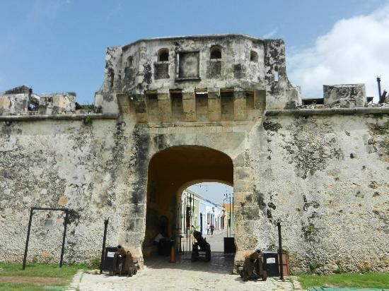
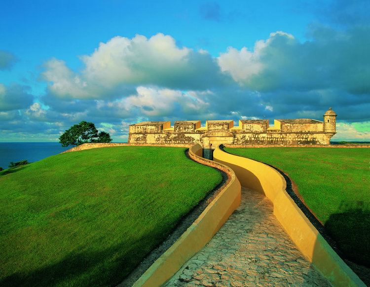
The Spanish introduced sugar cane and other crops in the area, starting in the 1540s, but the main value of the area was the port of Campeche, established in 1540 where the old Maya village used to be. During the colonial era, it was a commercial port equal to Havana and Cartagena even though piracy was a constant threat. It shipped valuable exports such as agricultural goods, tropical hardwoods and dyewood, then a widely used textile dye in Europe. It also handled gold and silver from other areas in Mexico going to Spain. Imported items to the port included luxury items such as Italian marble and crystal chandeliers from Austria . The Spanish built a European based colonial city here and as it became rich, it was filled with large mansions. However, to survive in the hot and humid environment, the Europeans also adapted a number of Maya products such as hammocks for sleeping and storing drinking water in hollow gourds. They also built with the area’s local red cedar, mahogany and “sahcab” a local limestone. The shipping in these waters attracted pirates such as John Hawkins, Francis Drake, Diego the Mulatto, Henry Morgan, Cornelis Jol, Bartolomeu Português, Lewis Scot and Roche Braziliano . Most of the attacks were at the port of Campeche, but Champontón also suffered significant attacks in 1644 and 1672. Fortification of the city of Campeche began as early as 1610, but these structures were insufficient. The worst pirate attack occurred in 1685, when Laurens de Graaf sacked the city of Campeche and the surrounding haciendas for over thirty days, killing about a third of the area’s population. This prompted far more extensive fortification with numerous forts and a wall around the city that measured 2,560 meters in an irregular polygon shape. Most of the forts survive but only 500 meters of the original wall remains. These fortification cut the threat of pirate attacks but it remained walled until 1890. Campeche was officially recognized as a city in 1774 (the first in southeast Mexico) and in 1784 was declared a minor port. In 1804, the port was closed due to the war between Spain and England. This caused discontentment in the city and fomented insurgent tendencies.
Campeche remained a wealthy and important port until the early 19th century, when a number of events brought on decline. In 1811, the port of Sisal was opened in what is now the State of Yucatán, taking much of the city’s business. Another issue was that Independence brought the abolition of slavery, cutting agricultural production. The lack of shipping made the city relatively isolated from Mexico City. From the 19th century until the latter 20th, the state’s economy was dependent on agriculture, fishing, logging and salt mining.
In September 1821, the city of Campeche proclaimed its adherence to the Plan of Iguala and the new Independent government of Mexico, forcing out its last Spanish governor a month later. At Independence, Campeche was one of the two most important cities on the Yucatán Peninsula, along with Mérida. There was political friction between the two. Campeche was the more liberal of the two, and supported the 1824 Mexican Constitution which established a Federal Republic. In 1824, Campeche’s representative proposed that the peninsula be divided into two states: Mérida and Campeche but this was not accepted. Political divisions intensified along with the nationwide struggle between Liberals and Conservatives .
Despite Campeche’s and Mérida’s differences, both were involved in an insurrection against Mexico City headed by Jerónimo López de Llergo in 1839 with the aim of creating an independent state of Yucatán. After initial victories, López de Llergo proclaimed the peninsula independent and in 1841, the Constitution of the Yucatán was promulgated on federalist principles. Yucatán independence did not solve the peninsula’s internal political problems. Mérida’s trade with Havana continued but Campeche’s trade with Mexico City was cut off. Campeche wanted to rejoin Mexico for this reason and Andrés de Quintana Roo tried to work out a settlement between the two cities. Mexican president Santa Anna then sent an expedition to force the Yucatán back into Mexico. More fighting came with the outbreak of the Caste War, in 1847, an indigenous rebellion that took place in Campeche and the rest of the Yucatán. This and foreign pressure to pay debts, forced the Yucatan to formally reintegrate into Mexico in 1849.
The Mexican Constitution of 1857 completely broke the schism between Campeche and Mérida with various rebellions breaking out. During one of these 150 men took over one of the main forts of Campeche and demanded a political union consisting of it, Champotón and Isla del Carmen. Other settlements in the west of the peninsula expressed its desire to be partition with these areas as a new state. In 1858, representatives from Campeche and Mérida signed an agreement to divide the peninsula, which was ratified to make the division official.
During the French Intervention in Mexico, forces under Felipe Navarrete took Campeche and forced the state to rejoin the rest of the Yucatán. In 1864, insurgents defeated the imperial army in Hecelchakán and in 1867, they retook Campeche to regain the state’s independence.
During the Mexican Revolution, Manuel Castilla Brito took up arms in Campeche in support of Francisco I. Madero. However, the insurgents were defeated by General Manuel Rivera, a Victoriano Huerta supporter in 1913. Forces loyal to Venustiano Carranza entered Campeche in 1914. Slavery and serfdom was abolished on the haciendas. In 1917, Campeche wrote its current constitution.
There was some improvement in the state’s economy starting in the 1950s when fishing and timber industries became more developed and there was better communications between the state and Mexico City. In 1955, the University of Campeche was founded and a state system of middle schools was begun. However, Campeche’s main economic change come with the discovery of oil off its shores in a shallow water region called the Sonda de Campeche. This oil was discovered by a fisherman named Rudesindo Cantarill in 1971, who reported an oil slick. In 1975, the first oil platform, called Chac Number One began operations. The first set of offshore platforms were completed by 1979. The find has made the state the top producer of petroleum in Mexico, providing 70% of all oil pumped in the country. The economic boom tripled the population of the city of Campeche in ten years, and nearly doubled that of Ciudad del Carmen, which before was only a small fishing village. However, the production of oil has brought environmental problems to the area, especially fishing yields, as well as internal strife between locals and newcomers.
In the mid-1980s, about 25,000 Guatemalan refugees had fled into the state to escape civil war there .
The oil money allowed for the revitalization of the city of Campeche starting in the 1980s. The State Office of Cultural Heritage Sites and Monuments bought abandoned properties to restore them for use as museums, schools, theaters and a library. More than a thousand facades and monuments have been refurbished in the historic center and the oldest residential areas.
In the 1990s, a number of textile mills of the “maquiladora” type were opened in the state. The capital was declared a World Heritage Site by UNESCO .
The most recently created municipality is Candelaria in 1998.
Culture
The state has two main government sponsored cultural festivals, the Festival del Centro Histórico and the Festival de Jazz. Campeche has a Festival del Centro Histórico in November and December, which attracts over 5,000 artists, intellectuals and academics to over 800 events such as concerts, theater, dance, book presentations, and workshops. The Festival de Jazz was begun in 1999 and has had the participation of figures such as Mike Stern, Caribbean Jazz Project, Yazzkin, Chano Domínguez, Eugenio Toussaint, David Gilmore and Scott Henderson . One notable economic fair outside of the city is the “Jipi” Sombrero Festival in Bécal in April and May.
The largest religious festival in the state is Carnival in the city of Campeche. Carnival was introduced in 1582. By 1688, the annual event featured orchestras and in 1815, formal dances called “saraos” were organized which originally were held only in the homes of the elite. Later in the 19th century, events in the streets for the masses became popular, with the various neighborhoods of the city organizing their own events. Eventually, these merged into a city-wide celebration featuring various traditional dances such as Baile del Pavo, Son de la Cucaracha, the fandango, fandanguillo and various forms of tropical jaranas. They also include more risqué dances such as those called la Culebra, Los Papagayos and la Contradanza de los Palitos which have Afro-Caribbean influence . Other important religious festivals include Candlemas (Candelaria) in Hool, Champotón and Campeche, feast day of Our Lady of Mount Carmen in Ciudad del Carmen, feast day of Saint Joachim in Palizada, and the feast day of Saint Roman in Campeche, the feast of San Isidro Labrador in Calkiní in May, the feast of the Cristo Negro in San Román, Day of the Dead in all of the state, feast of the Holy Cross in Sabancuy, Carmen in May, feast of Our Lady of Mount Carmen in Ciudad del Carmen in July and the feast of the Señor de la Salud in Hecelchakán in April. During these festivals is when the state’s most traditional music, called jarana, and traditional dances can be heard and seen.
As a Mayan region, Campeche has had corn as its staple since the pre Hispanic period, accompanied by beans, vegetables, tropical fruits and seafood, with some meat. There are two main types of cuisine. Mestizo is mostly of Spanish origin with some indigenous additions and the other is called Maya and is almost purely indigenous. Some foods have been reinvented. One is papak’sul, or papadzul, which was made with beans and chili peppers. Today it is a torilla filled with cooked egg and squash seed salsa. Common seasonings are a mix of indigenous and those which came from Europe such as salt, oregano, pepper, habanero chili peppers, achiote, cloves and vinegar. Regional dishes include cochinita pibil, beans with pork, pork with achiote, panuchos, empanadas, chanchanes, chocolomo, tamales, shark tacos, pickled vines, seafood such as many species of fish, shrimp, octopus and crustaceans. Similar to cochinita pibil, pibipollos are chickens roasted in underground pits, most often prepared for Day of the Dead. There is also a large number of seafood based dishes such as pan de cazón. One notable shrimp dish is made with giant prawns and called “siete barbas.” Tamales are filled with ground pork or chicken seasoned with achiote, pibil or sweet corn. The staple bread is the corn tortilla. The town of Pomuch in the municipality of Hecelchakán is known for its bread and has a type named after it.(turimsoenc) Cheese was mostly likely influenced by pirate with queso de bola related to Dutch cheese making traditions.