
Population 16,402 (2011 Census) Civil parish Campbell Park Region South East Dialling code 01908 | OS grid reference SP861395 Unitary authority Country England Ceremonial county Buckinghamshire UK parliament constituency Milton Keynes North | |
 | ||
Fanzone setup at campbell park milton keynes
Campbell Park is a district in east-central and south-central Milton Keynes, England, the central park for Milton Keynes, and (As of 1 April 2012) a ward of Central Milton Keynes Parish Council.
Contents
- Fanzone setup at campbell park milton keynes
- Map of Campbell Park UK
- Mk news visits campbell park after uci cyclo cross world cup
- The Park
- Civil parish
- Fishermead
- Oldbrook
- Springfield
- Winterhill
- Other Campbell Parks
- References
Map of Campbell Park, UK
Despite the loss of its eponymous district to another parish, the name Campbell Park continues to be used for a civil parish that includes other districts. According to the 2001 census the parish (then including the Park) had a population of 13,364.
Mk news visits campbell park after uci cyclo cross world cup
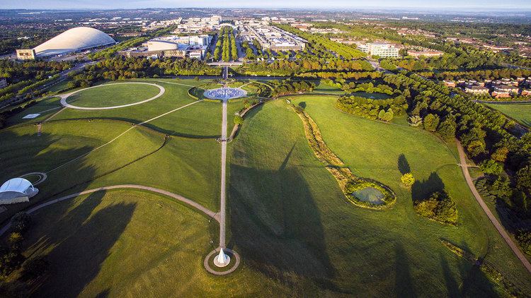
The Park
The park, also known as Campbell Park, takes up the larger part of the district. It was named in honour of the first chairman of Milton Keynes Development Corporation, Lord Campbell of Eskan. It stretches from the Theatre end of Central Milton Keynes down to the Grand Union Canal. A marina is planned for the canal here and it is the planned junction for the proposed Bedford Arm.
Civil parish
Campbell Park is a civil parish in the borough of Milton Keynes. The parish is bounded by Childs Way (H6) to the north, the River Ouzel to the east, the A5 to the west, and Chaffron Way to the south. The parish includes the Fishermead, Oldbrook, Springfield, Winterhill, and The Woolstones grid-squares. The parish was originally known as Woolstone-cum-Willen and was formed on 1 April 1934 as a merger of Great Woolstone, Little Woolstone and Willen. The parish was part of Newport Pagnell Rural District until it became part of the borough of Milton Keynes in 1974. The parish was redefined in 2012, when the districts of Campbell Park (sic), Newlands and Willen were reallocated to other parishes. Despite the loss of its eponymous district, the Parish Council continues to use its name.
Fishermead
Fishermead is named after a field called Fishers Mead. The fishing theme is continued in the street naming. All of the streets are named after Cornish fishing villages. There are two schools in the area, The Willows (formerly Newlyn Place) first school and Jubilee Wood School (formed by the amalgamation of Penwith first school and Meadfurlong middle school in 2012). Fishermead is known for its many trees and parks, with several local shops including a co-op and three fast-food vans.
The BT telephone exchange known as 'Bradwell Abbey' that serves Central Milton Keynes and the surrounding districts is located here, at the bottom of Helford Place – about three miles east of the real Bradwell Abbey.
Fishermead has a mixed population which reflects the demographics of Milton Keynes in general however the proportion of immigrants may be higher here with larger communities of Somalis and more recently, eastern Europeans.
The area was the location of a double shooting in 2011 which left two somali teenagers dead.
Oldbrook
Oldbrook is separated from Central Milton Keynes by Child's Way (H6). Despite its proximity to Central Milton Keynes, it has its own local centre comprising various shops and restaurants including Lidl, Domino's Pizza, Tesco Express, and Pizza Hut. Oldbrook is also home to Milton Keynes Christian Centre which is one of the larger churches in Milton Keynes. There is one school in Oldbrook, Oldbrook First School, situated next door to The Cricketers pub on Oldbrook Blvd.
All of the streets are named following a cricketing theme, most after English cricketers.
Springfield
Springfield is a residential area situated close to Central Milton Keynes. It sits between the districts of Fishermead, Peartree Bridge and the Woolstones. There are two schools in the area, Orchard and Shepherdswell Academy (Formerly Orchard School and Shepherdswell First School).
Both schools are now run by EMLC Academy Trust. The principals of the two schools are Mr Jonathan Cursely (Shepherdswell) and Mr Matthew Shotton (Orchard). Orchard Academy received its best Ofsted ever in June 2014 when the school was judged to be Good with many outstanding features. Orchard is an ever growing school, becoming a three form entry school as of September 2015.
Springfield has a local pub, community centre and a Tesco Express convenience store. The Grand Union Canal runs by Springfield into nearby Peartree Bridge.
Winterhill
Winterhill is the most westerly district of the parish, butting up as it does to the West Coast Main Line, south of and convenient to Milton Keynes Central railway station. It is a small district, split from the rest (Knowlhill) of its natural grid square by the railway line and the A5. It consists primarily of 'big shed' retail outlets and campus style offices.