
Area 442.8 km² | ||
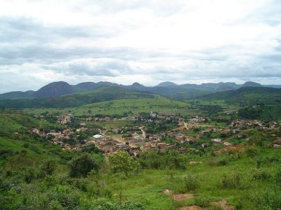 | ||
Campanário is a Brazilian municipality located in the northeast of the state of Minas Gerais. Its population as of 2007 was 3,592 people living in a total area of 441 km². The city belongs to the meso-region of Vale do Rio Doce and to the micro-region of Governador Valadares. It became a municipality in 1943.
Contents
- Map of CampanC3A1rio State of Minas Gerais Brazil
- Location
- Economic activities
- Health and education
- References
Map of Campan%C3%A1rio - State of Minas Gerais, Brazil
Location
The city center of Campanário is located at an elevation of 268 meters on the important federal highway BR-116 between Governador Valadares and Teófilo Otoni. Neighboring municipalities are: Itambacuri (W and N), Frei Gaspar (NE), Pescador (E), Jampruca (S).
Distances
Economic activities
Services and agriculture are the main economic activities. The GDP in 2005 was approximately R$15 million, with 9 million reais from services, 1 million reais from industry, and 4 million reais from agriculture. There were 190 rural producers on 19,000 hectares of land (2006). Approximately 450 persons were occupied in agriculture. The main crops are sugarcane, beans, and corn. There were 23,000 head of cattle, of which 3,700 were milk cows (2006). Only 25 of the rural properties had tractors in 2006.
There were no banks (2007) In the vehicle fleet there were 161 automobiles, 10 trucks, 12 pickup trucks, 4 buses, and 70 motorcycles (2007).
Health and education
In the health sector there were 2 health clinics (2005). Educational needs of 1,100 students were met by 3 primary schools, 1 middle school, and 1 pre-primary school.
In 2000 the per capita monthly income of R$133.00 was below the state average of R$276.00 and below the national average of R$297.00. Poços de Caldas had the highest per capita monthly income in 2000 with R$435.00. The lowest was Setubinha with R$73.00.
The highest ranking municipality in Minas Gerais in 2000 was Poços de Caldas with 0.841, while the lowest was Setubinha with 0.568. Nationally the highest was São Caetano do Sul in São Paulo with 0.919, while the lowest was Setubinha. In more recent statistics (considering 5,507 municipalities) Manari in the state of Pernambuco has the lowest rating in the country—0,467—putting it in last place.