Frazioni Borgo Callea Demonym(s) Cammaratesi Area 192.3 km² Local time Tuesday 12:13 PM Postal code 92022 | Elevation 682 m (2,238 ft) Time zone CET (UTC+1) Dialling code 0922 | |
 | ||
Weather 7°C, Wind W at 39 km/h, 71% Humidity | ||
Elezioni comunali cammarata 2015 atto 1 i sorci verdi
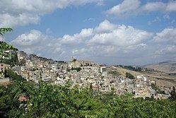
Cammarata is a comune (municipality) in the Province of Agrigento in the Italian region Sicily, located about 60 kilometres (37 mi) southeast of Palermo and about 35 kilometres (22 mi) north of Agrigento on the eponymous mountain, which has an elevation 1,578 metres (5,177 ft) above sea level in a territory rich in forests.
Contents
- Elezioni comunali cammarata 2015 atto 1 i sorci verdi
- Map of 92022 Cammarata Province of Agrigento Italy
- History
- Main sights
- References
Map of 92022 Cammarata Province of Agrigento, Italy
Cammarata borders the following municipalities: Acquaviva Platani, Casteltermini, Castronovo di Sicilia, Mussomeli, San Giovanni Gemini, Santo Stefano Quisquina, Vallelunga Pratameno, Villalba.
History
The name derives from the Greek Kàmara, meaning "vaulted room".
King Roger I laid siege to the Cammarata in 1087 and sold it to a relative Lucia d'Altavilla (or in English Lucy of Hauteville). She then assumed the title Dominae Camaratae or Lucy of Cammarata for the town she was given
The town is mentioned in 1141 in a document mentioning several Arabic localities, a sign that it was settled at least from the Islamic domination of the island.
The county of Cammarata followed the history of Sicily under the Normans, the Hohenstaufen and the War of the Vespers. In 1397 the count rebelled and the town was besieged by Bernardo Cabrera, general of king Martin II of Sicily. Later it was a fief of the Abatellis.
