
Primary outflows Azopardo River Max. length 98 km (61 mi) Max. depth 200 m (660 ft) Area 645 km² Surface elevation 140 m Cities Tolhuin | Basin countries Argentina, Chile Surface area 645 km (249 sq mi) Settlements Tolhuin Length 98 km Outflow location Azopardo River | |
 | ||
Province Tierra del Fuego Province, Argentina | ||
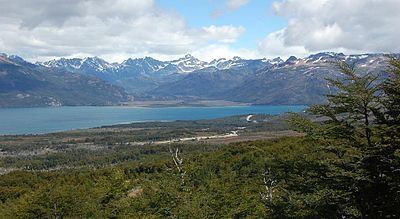
Fagnano Lake (Spanish: Lago Fagnano), also called Lake Cami (Spanish: Lago Cami), is a lake located on the main island of the Tierra del Fuego archipelago, and shared by Argentina and Chile.
Map of Cami Lake, Tierra del Fuego Province, Argentina
The 645 km² lake runs east-west for about 98 kilometres, of which 72.5 km (606 km²) belong to the Argentine Tierra del Fuego Province, and only 13.5 km (39 km²) belong to the Chilean Magallanes y la Antártica Chilena Region. It has a maximum depth of 200 meters.
The southern bank is steep compared to the northern, and expands in a considerably wide and flat piedmont from which both levels of the plateaus can be appreciated.
From its western end, the Azopardo River drains towards the Almirantazgo Fjord. On its eastern end is the town of Tolhuin.
The lake is located in a pull-apart basin developed along the Magallanes–Fagnano Fault zone.