Country Italy Elevation 608 m (1,995 ft) Area 382 km² Local time Tuesday 3:16 AM | Time zone CET (UTC+1) Dialling code 0933 | |
 | ||
Frazioni Albanazzo, Colleggiata (Collegiata), Favarella, Granieri, Mulino Buongiovanni, Piano Carbone, Piano San Paolo, Rangasia, San Basilio - Casa Prete, San Mauro, Santo Pietro, Serra Fornazzo, Signore del Soccorso, Villa Gravina, Villa Grazia Demonym(s) Calatini or Caltagironesi Weather 11°C, Wind SW at 18 km/h, 94% Humidity Points of interest Saint Maria of Monte, Luigi Sturzo Gallery, Museo Regionale della Cer, Musei Civici Luigi Sturzo, Galleria Civica d'arte Mo | ||
Caltagirone (Sicilian: Caltaggiruni) is a town and comune in the Metropolitan City of Catania, on the island (and region) of Sicily, southern Italy, about 70 kilometres (43 mi) southwest of Catania. It is bounded by the comuni of Acate, Gela, Grammichele, Licodia Eubea, Mazzarino, Mazzarrone, Mineo, Mirabella Imbaccari, Niscemi, Piazza Armerina, San Michele di Ganzaria.
Contents
- Map of 95041 Caltagirone Province of Catania Italy
- History
- Geography
- Main sights
- People
- Sister cities
- References
Map of 95041 Caltagirone, Province of Catania, Italy
The city is a production center of pottery, particularly maiolica and terra-cotta wares. Nowadays the production is more and more oriented to artistic production of ceramics and terra-cotta sculptures. Other activities are mainly related to agriculture (production of grapes, olives, peaches).
History
The city's name derives from the Arabic "qal'at-al-jarar" ("Castle of [pottery] jars") - a name that attests to the antiquity of the pottery works which are still thriving. It has been inhabited since prehistoric times, as shown by the presence of two necropolises dating from the second millennium BCE and by numerous other archaeological finds. It was later inhabited by the Sicels pre-Roman population.
The Arabs built a castle here that in 1030 was attacked by Ligurian troops under the Byzantine general George Maniakes, who have left traces of Ligurian language in the current dialect. The city flourished under the Norman and Hohenstaufen domination, becoming a renowned center for production of ceramics.
The city was almost completely destroyed by the earthquake of 1693. Many public and private buildings have then been reconstructed in earthquake Baroque style. Primarily for this reason the city has been included, together with the surrounding territory, in an area protected by the UNESCO World Heritage program.
Geography
The municipality borders with Acate (RG), Gela (CL), Grammichele, Licodia Eubea, Mazzarino (CL), Mazzarrone, Mineo, Mirabella Imbaccari, Niscemi (CL), Piazza Armerina (EN) and San Michele di Ganzaria. Its hamlets (frazioni) of Albanazzo, Colleggiata (or Collegiata), Favarella, Granieri, Mulino Buongiovanni, Piano Carbone, Piano San Paolo, Rangasia, San Basilio - Casa Prete, San Mauro, Santo Pietro, Serra Fornazzo, Signore del Soccorso, Villa Gravina and Villa Grazia.
Main sights
A collection of ancient and modern pottery and terra-cotta, dating back to the Magna Grecia period, is available in the local Museum of Pottery, created in 1965.
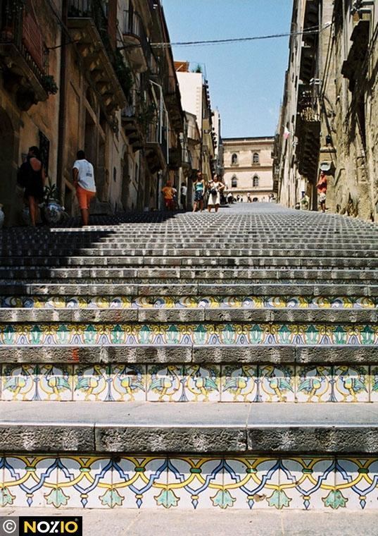
The main landmark of the city is the 142-step monumental Scalinata di Santa Maria del Monte (Staircase of Santa Maria del Monte), built from 1608 in the old part of the town. The peculiarity is that each step is decorated with different hand-decorated ceramics, using styles and figures derived from the millennial tradition of pottery making. Once a year, on and around the day of the city's patron saint, (St. James, 25 July), the staircase is illuminated with candles of different colours arranged in order to reconstruct an artistic drawing of several tens of meters.
Religious buildings include:
