
Length: 6.718 mi (10.812 km) | Existed: 1990 – present | |
 | ||
South end: Mexican border near Mexicali | ||
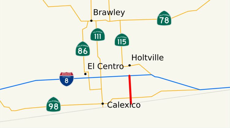
State Route 7 (SR 7) is a state highway in the U.S. state of California, running from the Calexico East Port of Entry on the U.S.-Mexico border east of Calexico north to its terminus at Interstate 8 (I-8), where Orchard Road continues the route north towards Holtville. The route provides convenient access to the country of Mexico from I-8. The southern portion of the route opened in 1996, and the rest of the route connecting to I-8 opened in 2005.
Contents
Route description
The highway begins at the Calexico East Border Station, which is open from 6 am to 10 pm, seven days a week. Just north of the border, the highway splits into two roads to pass through the customs checkpoints before the two roads merge back together; the fork to the west is for cars, and the fork to the east is for commercial vehicles. SR 7 takes the western fork, which passes over the other fork at the northern end and merges into that highway. From here to I-8, SR 7 is an expressway known as Orchard Road. Before reaching I-8, SR 7 travels north and has an at-grade intersection with SR 98 and a few other roads. At its northern end, SR 7 turns into County Route S32 (still Orchard Road) as it intersects with I-8. The entire route runs through the Sonoran Desert and is built to expressway standards.
The route was constructed to allow commercial traffic to travel between Mexico and the United States. SR 7 is part of the California Freeway and Expressway System, and is part of the National Highway System, a network of highways that are essential to the country's economy, defense, and mobility. In 2013, SR 7 had an annual average daily traffic (AADT) of 2,450 at the Calexico inspection station, and 15,900 at Menvielle Road along the spur, the latter of which was the highest AADT for the highway.
History
SR 7 was added to the state highway system in 1990, and to the Freeway and Expressway System in 1998. The segment from the Mexican border to SR 98 was completed by March 1996 to expressway standards; this cost $9.1 million (about $16.9 million in 2015 dollars) to complete. However, the border crossing was not opened until December 2, 1996, due to delays in constructing the Mexican portion of the border crossing. Because of the 1994 economic crisis in Mexico, there was not enough money to complete the construction of the road leading up to the border facility on the Mexican side, as well as the Mexican border facility itself. The segment from SR 98 to I-8 began construction in March 2004 at a cost of $64.5 million (about $85.9 million in 2015 dollars); however, it was completed in mid-2005.
Major intersections
Note: Postmiles do not necessarily reflect current mileage. "S" refers to mileage on the spur route of SR 7 towards the border. The entire route is in Imperial County.