
Counties: Humboldt | Length 14.14 km | |
 | ||
County | ||
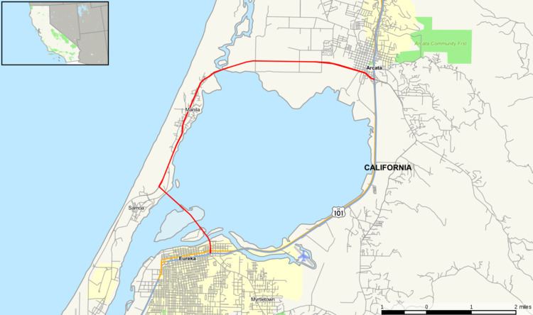
State Route 255 is a state highway in Humboldt County, California, United States.
Contents
Map of CA-255, California, USA
Route description
It is a western alternate route of U.S. Route 101 between Eureka and Arcata, routed via the three bridges over Humboldt Bay and Indian Island and Woodley Islands, rather than motorists having to circumvent the entire northern section of the bay (known as Arcata Bay) to the road connecting the Arcata area to the Samoa Peninsula. In literature and locally, the portion of the road crossing Humboldt Bay (on three separate bridges) is known collectively as the "Samoa Bridge."
Highway 255 provides direct access to industrial operations on the Samoa Peninsula and the communities of Samoa, Fairhaven, and Manila, all of which are located on the Samoa Peninsula, with the entire combined area located within Greater Eureka.
History
Before the Samoa Bridge (actually three spans) was completed in 1971, direct access to Samoa from Eureka was by boat or on a fleet of small ferries constructed on the bay or the original circuitous route. The original alternative was a relatively extensive route which took drivers north to Arcata and then around the bay to the northern peninsula before reaching the heavily industrialized area adjacent to Eureka. Completion of the Samoa Bridge and the creation and designation of Highway 255, completed a circle around Arcata Bay by connecting to the New Navy Base Road (a portion now designated as 255), along the peninsula connecting Samoa to the Eureka shore of the bay. This resulted in making the ferry system obsolete. However, one ferry, the Madaket, continues operating as a tour boat on Humboldt Bay.
Major intersections
Except where prefixed with a letter, postmiles were measured on the road as it was in 1964, based on the alignment that existed at the time, and do not necessarily reflect current mileage. R reflects a realignment in the route since then, M indicates a second realignment, L refers an overlap due to a correction or change, and T indicates postmiles classified as temporary (for a full list of prefixes, see the list of postmile definitions). Segments that remain unconstructed or have been relinquished to local control may be omitted. The entire route is in Humboldt County.